Please put an active hyperlink to our site (www.rusnature.info) when you copy the materials from this page
Physical Geography of Northern Eurasia
Climatic Change and the Development of Landscapes
Cryogenic Phenomena
<<< Quaternary Permafrost | Physical Geography Index | The Development of
the Hydrographic Network of Northern Eurasia >>>
Loess
Since the beginning of the Quaternary, cold epochs featured the formation of loess,
which points to the existence of extremely dry periglacial environments. The origin of
loess has been much debated, especially in relation to how sedimentation of fine particles
proceeded and the conditions under which sediment acquired the typical characteristics of
loess. The properties of loess are best explained by the aeolian hypothesis. It is most
likely that loess is windblown dust which was deposited and later subjected to diagenesis
in a dry and presumably cold environment. These ideas are in good agreement with the
occurrence of loess on interfluves, slopes, and high terraces. The loess material could be
partly redeposited by water. This process is typical of the foothills of the Central Asian
mountains.
In most regions, loess horizons alternate with fossil soils which often serves as a
marker in inter-regional correlations (Velichko, 1990). In such sequences, loess horizons
relate to the cold stages (glaciations) while the presence of soils indicate phases of
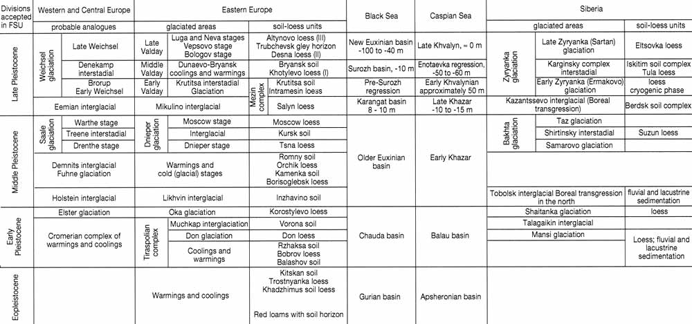
milder (interglacial or interstadial) climate (Table 2.1). At present, the best-studied
loess sequences are on the East European plain and in Western Siberia.

Table 2.1 Correlation of main paleogeographic events in Northern Eurasia
The oldest loess-like sediments on the East European plain are related to the
Eopleistocene when the formation of loess was restricted mostly to the extreme south. The
same is true of the lower and middle Pleistocene. The loess horizons dated to that time
are traced beyond the modern shoreline of the Black Sea on to the shelf. It is likely that
the deposition of loessial dust on the shelf occurred during the marine regressions.
Further north, the older loess is overlain by younger loess horizons dated to the late
Pleistocene. The younger horizons are most widespread and display typical characteristics
of loess. For example, grains of sands incorporated into loess, show distinct traces of
wind abrasion (Velichko and Starkel, 1994; Velichko and Timireva, 1995). The late
Pleistocene loess occurs on flat interfluves and river terraces where it is locally
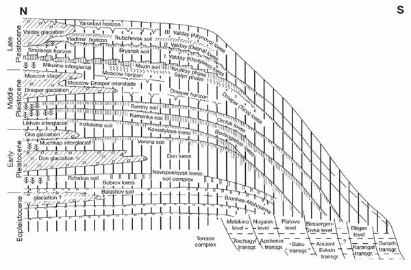
replaced by wind-blown sand. On the older terraces, there are usually several loess and
palaeosol horizons. The number of horizons progressively decreases towards younger
terraces (Figure 2.1). The late Pleistocene loess horizons attain their maximum thickness
(up to 10-12 m) between 48∞N and 52∞N, diminishing both northwards and southwards. Thick
loess occurs in the foothills of the Northern Caucasus and the eastern Carpathians up to a
height of 400-500 m.

Fig. 2.1 Principal paleogeographic components of the Quaternary on the
East European plain. Compiled by A. Velichko
A uniform composition of loess, observed across vast areas, suggests a wide zone of
provenance. The most probable sources of dust are glacio-fluvial and alluvial plains and
valley trains. Judging from the size of particles, the deposition proceeded under low wind
speeds, which did not exceed 2.5 m s-1 (metres per second). This conclusion is
in line with the idea that anticyclonic conditions dominated the periglacial zone.
However, loess characteristics vary between horizons, which may reflect environmental
changes during the cold phases of the Valday. Thus, an occasional presence of thin
bedding, a fairly high content of clay and sand particles and the small thickness of the
early Valday loess, suggest a reduced continentality of climate and a higher moisture
supply than during the later stages of loess accumulation. The late Valday was marked by
higher rates of loess deposition. It peaked a few hundred kilometres south of the ice
sheet limit, where the calm state of the atmosphere favoured the deposition of dust. On
the whole, apparently there was no direct relationship between ice sheet expansion and
intensity of loess deposition. However, ice sheets contributed to the formation of loess.
For example, melt-water streams kept the outwash plains free of vegetation while winds
blowing from the glacier blew silt off the exposed surface and deposited it to the
leeward.
Apart from the East European plain and Western Siberia, a thick series of loess and
fossil soils occur in the foothills of the Central Asian mountains and in the intermontane
basins. These series correlate well with the loess-soil series of the East European plain
(Table 2.1).
Finally, the so-called loess-ice complex, dated to the same cold phases of the late
Pleistocene as loess, is widespread on the coastal lowlands of Sakha-Yakutia and
north-eastern Asia. Its composition is similar to the loess of the East European plain,
but it is characterized by a high ice content and the presence of deep and thick
syngenetic ice veins. Although there is no general agreement on the origin of this
deposit, it is certain that part of it is subaerial and is similar to the typical loess of
the East European plain (Tomirdiaro, 1980).
<<< Quaternary Permafrost | Physical Geography Index | The Development of
the Hydrographic Network of Northern Eurasia >>>
|