Please put an active hyperlink to our site (www.rusnature.info) when you copy the materials from this page
Physical Geography of Northern Eurasia
Climatic Change and the Development of Landscapes
<<< Closed Inland Basins | Physical Geography Index | Cenozoic Climates:
The General Trend >>>
History of Vegetation
Vegetation is one of the most important landscape components whose evolution is
primarily controlled by climatic change.
In the early Cenozoic, Eurasia was dominated by thermophilic forest vegetation, which
exhibited weak latitudinal differentiation. The northern forests were of transitional type
between the subtropical and mild temperate and were distinguished by the presence of
deciduous species. Throughout the Paleocene and Eocene subtropical and tropical tree
species, such as Nipa and Sabal palms and representatives of Myrtaceae and Lauraceae
families, were found in abundance in the central and south-western regions of the East
European plain (Figure 2.9).
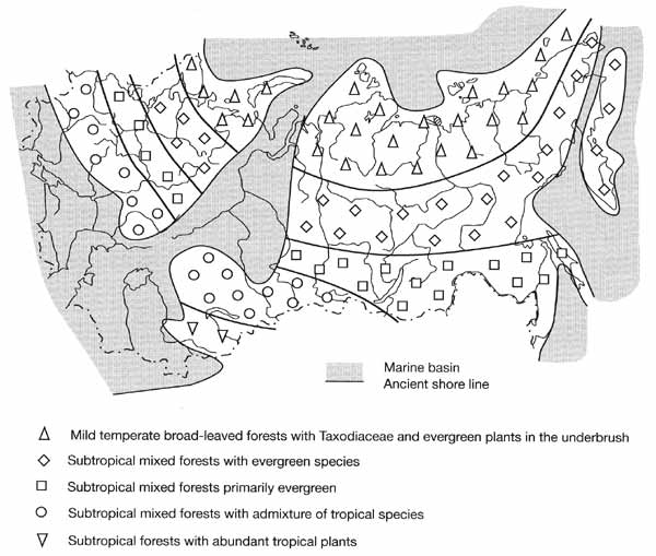
Fig. 2.9 Vegetation zonality during the Eocene optimum. Modified from
Sinitsyn (1980b)
In the south-eastern regions, vegetation was quasi-tropical, although it included
plants indicative of aridity, such as species of the Myrtaceae family and sclerophyllous
oaks. In Western Siberia, forests were dominated by tropical and subtropical taxa
(Engelhardtia and palms) typical of hot and humid climates. Similar vegetation (palms,
species of Myrtaceae and Santalaceae families) was widespread on the plains of Kazakhstan
and Central Asia, while the arid zone located further south became smaller. In
north-eastern Asia, the Eocene optimum was marked by the development of the most
thermophilic floras of the whole Cenozoic. However, the vegetation was different from that
of the vast quasi-tropical zone. Prevailing were polydominant broad-leaved forests of
Castanea, Juglans, and Carya with Engelhardtia, Nyssa, Liquidambar, and species of
Myrtaceae family. It is possible that during the Eocene climatic optimum the vast forest
zone was differentiated, with a subzone of subtropical or even mild temperate forests
existing in higher latitudes.
The second half of the Eocene and the early Oligocene were marked by a sharp decrease
in temperature. The Helinden flora was replaced by the Poltava flora in lower latitudes
while the Greenland flora was replaced by the Turgai flora in higher latitudes
(Krishtofovich, 1941). These changes varied regionally. They were less pronounced in the
south-west of the East European plain, probably due to the influence of the Tethys, and
forests preserved their subtropical character although their composition became poorer.
More pronounced changes were recorded in Western Siberia. Towards the end of the Eocene,
the subtropical tree species were replaced by the mesic small-leaved trees such as Betula
and Alnus. Distinct changes occurred in Kazakhstan and Central Asia. In the forest zone,
Quercus and Laurus forests became dominant. More arid environments developed southwards in
Uzbekistan and Turkmenistan, where shrubs became widespread together with Laurus and Rhus.
In north-eastern Asia, deciduous forests, including species adapted to a severe climate
such as dwarf birch and Alnaster, became widespread.
In the Oligocene, climatic cooling occurred across Eurasia. In the south-west of the
East European plain, climatic change in the early Oligocene was less pronounced, probably
due to the marine transgression. Pine and broad-leaved forests developed. The latter
included evergreen species, although their participation diminished towards the end of the
interval. In the central East European plain, forests were mainly composed of species
typical of the mild temperate zone, such as Carpinus, Betula, Ulmus, and Alnus, with the
participation of evergreen species of the Turgai flora. In Western Siberia, evergreens
disappeared and mesic deciduous forests with the participation of conifers became dominant
in the early Oligocene. The Turgai flora fully developed in the late Oligocene on the vast
lacustrine plains. In north-eastern Asia, the Turgai vegetation was represented by mixed
Pinus and Betula forests and, to a lesser extent, by mixed forests with Pinus, Conium
maculatum, Sequoia, and Fagus. Here and in central Sakha-Yakutia, the cold-tolerant
species became important at the end of the Oligocene and dwarf birch and Alnaster became
widespread in the mixed Pinus-Betula forests.
In the Neogene, the vegetation pattern changed considerably. At the beginning of the
Miocene, climatic cooling continued. The south-west of the East European plain was
dominated by forests similar to those now existing in the Northern Mediterranean. The
participation of subtropical species increased later in the Miocene, about 21-20 Ma BP
(during the first Miocene climatic optimum), and then again about 11.3-10.3 Ma BP (during
the second Miocene optimum). The latter was marked by the development of subtropical
forests with the participation of tropical species. Notable changes occurred north of the
Black Sea in the middle Sarmatian (10.3-9.0 Ma BP). Increasing aridity resulted in the
development of grass communities of a steppe type and the development of a new biome,
steppes, between 6.0 and 5.5 Ma BP. This interval coincided with the Messinian crisis.
In Western Siberia, the first Miocene optimum (20-18 Ma BP) was more pronounced than
the second optimum. Higher temperatures favoured the development of mixed broad-leaved
coniferous forests on the lacustrine plains.
The middle Miocene cooling resulted in the expansion of small-leaved tree species, in
particular Alnus, and the Turgai flora lost its distinct character. Aridity began
developing at the beginning of the late Miocene and reached its maximum during Pavlodar
time, which correlates with the Messinian crisis. Dry steppes with Artemisia and
Chenopodiaceae and semi-deserts developed in the south of the West Siberian plain, where
forest survived only in riparian locations.
The process of aridization was more conspicuous in Kazakhstan and Central Asia
throughout the Miocene. First, stable grass communities with representatives of Compositae
and Polygonaceae families, Artemisia and halophytes developed as early as the Burdigalian
(middle of the early Miocene). By the late Miocene, the steppe zone had extended from the
river Irtysh to Lake Balkhash.
Pine and birch forests with an admixture of conifers, Fagus, Tilia, Ilex, and Ulmus
dominated north-eastern Asia and central Sakha-Yakutia in the early Miocene. Later, during
the colder phases of the middle Miocene, they were replaced by mixed forests dominated by
conifers.
The Miocene marked the beginning of the development of the structural framework of
modern landscapes, although considerable restructuring occurred in the Pliocene, fn the
early Pliocene, climatic warming, and consequently, changes in vegetation occurred between
5.0 and 4.2-4.0 Ma BP. The 4.2-4.0 Ma BP interval represents the Pliocene thermal optimum.
In the southwest of the East European plain, forest-steppes typical of the end of the
Miocene were replaced by the broad-leaved forests of the mild temperate zone. During the
Pliocene optimum, subtropical species became widespread in these forests while herb and
grass communities were dominated by meadow and bog species.
In Western Siberia, climatic cooling continued at the beginning of the Pliocene
although climate was warmer than at present. The steppe formations dominated, while mixed
broad-leaved coniferous forests with Carpinus, Ulmus, Quercus, and Tilia occurred locally.
The climatic optimum, which began earlier in Western Siberia than on the East European
plain, was marked by a sharp increase in aridity favouring the development of desert
communities in the south of the plain. The mixed birch-coniferous forests were widespread
in higher latitudes in the Far East, on the northern coastal plains, and in the
intermountain basins of north-eastern Asia. In the southern Far East, broad-leaved forests
with a high diversity of species developed. During the second half of the Pliocene, in
response to the strong climatic cooling, forests were replaced by open woodlands and later
by tundra in the northernmost regions. In the south, dark coniferous forests developed.
The south-east of the East
European plain and southern Western Siberia featured dry steppes with some tundra
elements, with aridity increasing eastwards.
Throughout the Eopleistocene stage (1.6-0.7 Ma BP) of the Quaternary, climatic
fluctuations occurred against the background of general climatic cooling and aridization.
Best researched are climatic fluctuations on the East European plain, where a number of
warm climatic phases occurred. In the south, climates were close to subtropical and forest
communities dominated. In the central part, mixed broad-leaved coniferous forests with
some subtropical taxa developed. During the colder phases, cold steppe landscapes,
precursors to later periglacial steppes, developed and open woodlands containing
coniferous, and rarely, broad-leaved trees occurred locally (Grichuk, 1989). Tundra,
forest-tundra and periglacial steppes existed in Western Siberia, the Lena basin and the
north-east of Eurasia (Velichko, 1998). In Central Asia, sedimentary sequences in
forelands and intermontane basins have revealed alternating drier (recorded in loess
horizons) and wetter (recorded in fossil red and red-brown soils) stages.
The frequency and range of climatic fluctuations increased in the Pleistocene. During
cold stages, zonal differences diminished and the hyperzonal structure of landscapes
developed (Velichko, 1989). Climates of the interglacial stages of the lower Pleistocene
were similar to those of the Eopleistocene, as indicated by subtropical fossil soils in
the south of the East European plain (Morozova, 1981) and the presence of the American and
East Asian tree species in pollen spectra. Typical steppe vegetation has been
reconstructed in the south-east of the plain while the rest belonged to the forest zone.
Mixed broad-leaved coniferous forests with Fagus, Juglans, Pterocarya, and Tsuga developed
south of 57-58°N, while in the north birch and birch-pine forests with a few broad-leaved
species dominated (Grichuk, 1989). During the last interglacial of the lower Pleistocene,
which followed the maximum Don glaciation, the zonal pattern on the East European plain
was similar to that of the previous warm stages although some changes occurred in the
forest zone. The proportion of broad-leaved species, such as Fagus and Zelcova, indicative
of mild environments, was reduced and the area occupied by mixed broad-leaved coniferous
forests decreased. In the north of the plain, coniferous forests with some broad-leaved
species retreated to 57-59°N and further north typical boreal formations of Betula and
Betula-Pinus forests became widespread.
Similar vegetation existed in Siberia. In the southern Far East, forests developed
throughout the early Pleistocene, although their composition changed. At the beginning of
the interval deciduous species dominated while at the end of the interval forests were
composed of dark coniferous species.
The interglacials (Likhvin in the East European plain and Tobolsk in Siberia), which
occurred at the beginning of the middle Pleistocene, are relatively well studied. The
structure of vegetation was similar to that of the previous interglacial of the lower
Pleistocene. Outside the limited steppe zone, vast areas reaching to the northern coast
were occupied by forests subdivided into three latitudinal belts: the mixed broad-leaved
coniferous belt; coniferous forests with the participation of broad-leaved species; and
Picea-Betula forests (Grichuk, 1989). In the mixed broad-leaved coniferous forest belt,
which was most extensive, flora included such species as Fagus, Castanea, Juglans,
Pterocarya, and Zelcova. Many representatives of this flora have survived until the
present, in contrast to the species which dominated the earlier floras. The fossil soils
dated to this period reveal signs of prairie only (as opposed to subtropical) soil
formation even in the south of the East European plain (Morozova, 1981). In Western
Siberia during the interglacial optimum, the middle taiga occurred in the northern
regions, reaching to the Arctic coast; the southern taiga developed in the central part;
and forest-steppe and steppe occurred south of approximately 56°N. In Eastern Siberia,
the earlier warm phases of the middle Pleistocene featured forest-tundra communities such
as Larix and Betula open woodlands and shrub tundra. Generally, analysis of vegetation
reveals the evolution of a more severe climate in the middle Pleistocene.
The best studied are the environments of the late Pleistocene (Grichuk, 1984). The
zonal pattern reconstructed for the interglacial (Mikulino in the East European
stratigraphic schemes and Kazantsevo in the Siberian one), which marked the beginning of
the interval, was very different from the modern one (Figure 2.10).
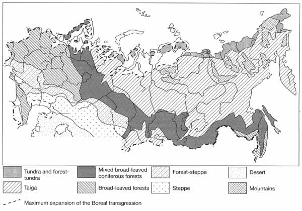
Fig. 2.10 Vegetation in the late Pleistocene interglacial optimum. After
Velichko et al. (1998)
On the East European plain, steppes occupied a larger area in comparison with the
previous interglacials and reached as far north as the middle courses of the Volga, Don,
and Dnieper, although small woodlands occurred locally as indicated by the presence of
forest soils amongst prevailing chernozems. Most of the plain was covered by forests
composed of Carpinus, Quercus, and Tilia with the participation of Betula and conifers.
Forests extended to 60°N in the west and 56-57° in the east. Vegetation communities,
typical of Western Europe at present, were widespread and brown forest soils dominated the
region. North of 60°, coniferous forests developed with the participation of broad-leaved
species, and a narrow coastal strip was dominated by coniferous and open Betula woodlands
(Gerasimov and Velichko, 1982).
In the south of the West Siberian plain, forest-steppes developed while the herb-grass
and grass steppes have been reconstructed for southern Kazakhstan and Central Asia. The
boundary between steppes and deserts was located in the region of modern deserts. Further
east, in southern Central Siberia (the Minusinsk depression), in the Transbaikalian region
and locally along the Amur, isolated patches of steppe vegetation occurred. The southern
taiga occupied the central regions of Western Siberia and the northern taiga developed
northwards, reaching the Arctic coast. Pinus and Larix forests were widespread in the
mountains of Eastern Siberia as they are today. In central Sakha-Yakutia, forests with
Pinus sibirica developed, indicating that the climate then was milder than now. Similarly,
Larix and Betula forests of the northern taiga type reveal that the coastal lowlands of
north-eastern Asia, including the lower Kolyma region, also experienced a milder climate.
In the southern Far East, the interglacial optimum was marked by a notable rise of the
ocean level (by 8-10 m) and the development of broad-leaved forests of the Manchurian
type.
The paleobotanic evidence obtained from the sediments postdating the optimum reveals
that severe climatic conditions developed on the East European plain. There is a
considerable decrease in the proportion of tree pollen and only the proportion of Betula
pollen increases. It is likely that Betula forests became widespread, although the share
of dwarf birch pollen, typical of the forest-tundra and northern taiga, is large. The
accumulation of loess also testifies to the colder climate and sparse vegetation. Forests
were replaced by open landscapes. This tendency is clearly traced throughout the short
warmer interval (the Krutitsa interstadial correlated to the Brarup). The chernozem-like
fossil soils, dated to this interval, are found in many localities where broad-leaved
forests and brown forest soils have been described in the Mikulino horizons (Morozova,
1981). Further decline of forests and the development of open landscapes marked the
subsequent cooling dated to 70-50 Ka BP (the early Valday). It was followed by a warmer
interval (the optimum of which occurred between 35-32 Ka BP and 25-23 Ka BP) when the
taiga forests were widespread in the central East European plain and the forest-tundra and
tundra developed in the north.
In Western Siberia, the post-Kazantsevo (early Zyryanka) cold stage, which is
correlated with the early Valday of Eastern Europe, apparently resulted in the degradation
of the dark coniferous forests and the replacement of the southern herb and grass steppes
by the periglacial cold steppes. However, during the subsequent warming, both climate and
vegetation were similar to those of today. This warm interval (with the optimum at 30-22
Ka BP) is often considered as an interglacial (Arkhipov et al, 1993).
In the East European plain and Siberia, the middle Valday and middle Zyryanka warming
was followed by the coldest stage of the whole Pleistocene known as the late Valday or
late Zyryanka (Sartan) glaciation. As in previous glacial ages, a hyperzonal structure of
landscapes developed with a dominance of open landscapes (tundra, periglacial steppe, dry
steppe, semi-deserts, and deserts) and a diminished forest zone. Mixed and broad-leaved
forests survived locally in refugia and probably in the southernmost regions of the Far
East, where their boundary shifted southwards by about 10 degrees latitude.
During the transition to the Holocene, warmer periods (Boiling and Allerod) alternated
with the cooler (Oldest Dryas, Older Dryas, and Younger Dryas) stages every few thousands
of years. These fluctuations were similar to those of the Holocene, although the latter
proceeded at a higher thermal level and showed a smaller range and longer period.
Recent investigations have shown that the taiga-tundra ecotone was dynamic and that the
forest and tundra zones underwent a considerable transformation during the interval.
Changes in vegetation varied considerably between the western and the eastern regions.
The paleobotanic studies carried out in the Pechora and Northern Dvina basins, have
shown that tree vegetation developed in the Allerod but periglacial landscapes were
restored shortly in the Younger Dryas. During the Preboreal, Pinus and Betula forests
developed in the areas now occupied by taiga, although towards the end of the Preboreal
tundra elements became prevalent again. The environment changed considerably during the
Boreal optimum. Forests advanced at least 100-200 km north of their present limit. The
dark coniferous forests developed up to 64°N and the northern taiga with Betula occurred
further north (Khotinsky, 1984). However, at the end of the Boreal optimum, climatic
cooling resulted in the replacement of forests by tundra. During the Atlantic, forests
with Larix and Pinus sibirica advanced northwards and the late Atlantic interval (6-5.5 Ka
BP) is known as the main climatic optimum of the Holocene (Figure 2.11).
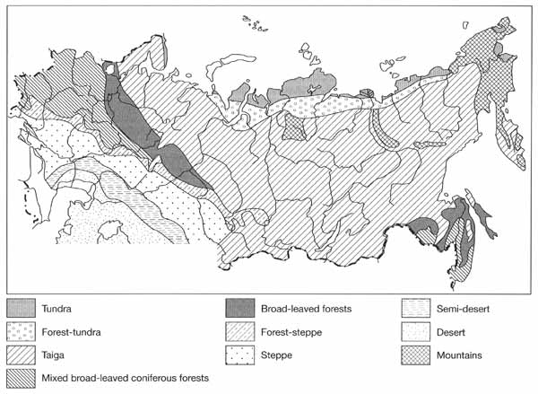
Fig. 2.11 Vegetation in the Holocene optimum. After Velichko et al.
(1998)
During the optimum, southern taiga with the participation of Quercus, Ulmus, Acer, and
Corylus avellana developed about 200 km north of its modern limit in the place of the
middle taiga. The middle taiga subzone moved 450-500 km north, and northern taiga forest
developed along the Barents coast. Since the first half of the Subboreal, progressive
cooling occurred and zonal boundaries shifted by 100-300 km southwards. After a short
warming in the second half of the Subboreal, when forest species were widespread, the
tundra zone gradually expanded to its modern size.
Similar sequences of climatic fluctuations have been reconstructed for Western Siberia
and the Far East. In Siberia, the climatic optimum also occurred at the end of the
Atlantic (6-5.5 Ka BP). Broad-leaved trees (Ulmus, Tilia, and Quercus) advanced up to
60°N along the Ob valley and forests composed of Alnus and Betula spread into the tundra
zone.
On the Taymyr peninsula, the climate in the late glacial (11-10.3 Ka BP) was more
severe than at present and tundra existed in place of the modern open Larix woodlands.
However, during the Preboreal, the position of forest-tundra approximately corresponded to
the modern one. Later, during the Boreal optimum, the forest-tundra with Picea and Betula
advanced northwards, into the regions of the modern arctic tundra. Larix wood found in the
modern tundra zone and dated to about 5.5-5.7 Ka BP indicates that the Atlantic optimum
was marked by the further decline of tundra vegetation. During the Subboreal cooling,
tundra expanded southwards.
Further eastwards in the Yana basin, shifts in the vegetation zones were less well
expressed. The analysis of vegetation zone dynamics in various regions has shown,
therefore, that in the west a shift in zonal boundaries was stronger than in the east.
This can be attributed to the eastward decrease in intensity of the westerlies.
In the Far East, the middle Holocene interval, considered as the climatic optimum
(7.5-4.9 Ka BP), was marked by the wide development of polydominant broad-leaved forests
with a number of thermophilic species.
<<< Closed Inland Basins | Physical Geography Index | Cenozoic Climates:
The General Trend >>>
|


