Please put an active hyperlink to our site (www.rusnature.info) when you copy the materials from this page
Physical Geography of Northern Eurasia
Climatic Change and the Development of Landscapes
<<< Climatic Change and the Development of
Landscapes | Physical Geography Index | Cryogenic Phenomena: Glaciations >>>
General Physiography of Northern Eurasia in the Cenozoic
When analysing the evolution of landscapes and climates of such a vast region,
physiographic features which gradually developed during the meso-Cenozoic interval (termed
'geomorphic stage' by Gerasimov et al., 1974) require consideration.
At the beginning of the Cenozoic (see Table 1.1 for geochronology), about 66 per cent
of Northern Eurasia, including the European territory, Western Siberia, the Turanian
lowland, and the Central Siberian plateau, was a platform on consolidated basement and its
planated surface was covered with weathering crust. Subsequently, the platform experienced
epeirogenic movements resulting in transgressions of epicontinental seas. Other areas were
montane regions of different ages, including young mountains, such as the Caucasus, the
mountains of Central Asia and Kamchatka, and rejuvenated (epiplatform) mountains.
The Paleogene (65-24.6 million years [Ma] BP) featured predominantly weak tectonic
activity across most of the continent (as indicated by the widespread epicontinental seas
and planation surfaces on adjacent land) and a warm climate (Sinitsyn, 1980a, b). However,
sea basins diminished during the late Eocene and Oligocene as a result of general
(although intermittent) uplift of the continent and probably a global decline in ocean
level caused by the onset of glaciation. Consequently, by the end of the Oligocene most of
the East European plain had emerged as a land mass.
Throughout the Oligocene, a vast inland lake-sea basin in Western Siberia became
detached from the withdrawing Paratethys. The Turanian lowland and plains of Kazakhstan,
submerged in the middle Oligocene, began to rise at the end of the period. The most
intensive uplift occurred in southern Central Asia, where large volumes of clastic
materials accumulated at the base of the growing mountains. The Mesozoic fold belts of the
north-eastern regions of Northern Eurasia experienced planation, while volcanic activity
continued in the south and in the east.
Throughout the Paleogene, the climate of the plains was uniform and hyperzonality (a
phenomenon referring to the expansion of a particular vegetation zone) was characteristic
of the region. Forests dominated most of the continent. However, at the end of the period,
climatic cooling brought about gradual changes in forest composition. Tropical and
subtropical species declined and the development of latitudinal zonality began. Most of
the first-order morphological units developed during the following Neogene stage (24.6-1.6
Ma BP).
In the Miocene, the uplift of the East European plain continued and topography became
inreasingly dissected. All major uplands and lowlands (the Srednerusskaya (Central
Russian) and Privolzhskaya uplands, the Donetsk Ridge and the Oka-Don lowland) were
formed. Under the warm, wet conditions, surface runoff was abundant and intensive erosion
developed. In southern regions, a sequence of transgressions and regressions occurred
although the general trend was that of regression. However, a single marine basin existed
in the place of the modern Black and Caspian Seas even during the regressions when the sea
retreated to the southernmost part of the plain. During the transgressions, the Caspian
Sea spread northwards and eastwards, sometimes merging with the Aral Sea.
In Western Siberia, flat topography and a humid climate favoured the accumulation of
fine sediments in valleys and large lakes since the Oligocene. The area of sedimentation
was shrinking gradually and retreated south-eastwards in the late Miocene. The Kazakh
shield, as well as the eastern and south-eastern regions of the West Siberian platform,
experienced an uplift during the Neogene, particularly in the mountainous regions of
Southern Siberia, and were subject to differentiated erosion. In the extreme north-east of
Northern Eurasia, the Miocene was characterized by weak tectonic activity and planation
except for the Koryak upland and Kamchatka which experienced folding and active volcanism
(Rezanov and Naimark, 1982; Olyunin, 1982).
The cooling trend persisted throughout the Miocene, although climatic warming occurred
at least twice which resulted in the formation of a complicated zonal structure and the
development of new biomes. Most importantly, steppes formed in southern Western Siberia
and Kazakhstan in response to increasing aridity. Their development proceeded most
intensively at the time of the Messinian crisis in the Mediterranean.
The Pliocene was marked by active orogenesis in the southern and eastern regions of
Northern Eurasia. Locally, in Transcaucasia and Kamchatka, it was accompanied by intensive
volcanism. The topography of the southern periphery of the East European plain became more
dissected as a result of the rapid uplift of the mountains (particularly in the middle
Pliocene) and tectonic subsidence in the southern Caspian basin. These processes also
contributed to fluvial dissection in the Caucasus (Dumitrashko, 1974). Similar processes
occurred in the south of the Turanian platform as indicated by the intensive deposition of
coarse material throughout the Pliocene. On plains, the drainage network acquired a
pattern similar to that of today. Thus, by the end of the Pliocene, the principal
physiographic units of Northern Eurasia, which are recognized today, had formed.
In parallel with the large-scale restructuring of topography, climate changed gradually
with warmer and colder phases alternating against the background of progressive cooling.
One of the most pronounced warm phases was the Pliocene climatic optimum (approximately
4.2-4.0 Ma BP). In Central Asia and on the plains of Southern Siberia, aridity increased
in response to the mountain-building, which isolated these regions from the influence of
the Indian Ocean. Of great importance was a period of strong cooling which occurred
between 2.7 and 2.1 Ma BP. Since that time, negative winter temperatures became typical
over most of the plains. The first ice sheet may have spread across Scandinavia and valley
glaciers may have developed in the mountains of the north-east region of Northern Eurasia
at that time. Sediments dated to that interval reveal distinct evidence of permafrost
occurrence (the Kutuyakh suite of north-eastern Siberia). A zonal structure similar to
that of the present developed.
The Quaternary is the latest and the shortest period (1.6 Ma, according to the current
chronostratigraphic schemes). It is subdivided into two units: Pleistocene (1.6-0.01 Ma
BP) and Holocene (the latest 10.3 thousand [Ka]). In Russian-language paleogeographic
literature the Quaternary is often subdivided into three units of different duration:
Eopleistocene (1.6-0.7 Ma BP), Pleistocene (0.7 Ma BP - 10.3 Ka BP), and Holocene (the
latest 10.3 Ka). During this period, as in the previous stages, landscape evolution was
controlled by climatic change. What distinguishes the Quaternary from the previous epochs
is that climatic cooling intensified. The temperature of each subsequent cold phase was
lower than that of the preceding one and temperatures during the warm phases also declined
progressively. Consequently, glaciations and the formation of permafrost, which originally
developed in the Neogene, peaked during the Quaternary. In contrast to the previous
stages, when climatic change resulted in the shift of zonal boundaries, cold and arid
phases of the Quaternary featured hyperzonality (open landscapes with the significant
participation of xerophytes in plant communities became widespread). A characteristic
product of cold and arid environments with scarce vegetation was loess. In the Quaternary
sequences, loess horizons alternate with fossil soils (Figure 2.1). The presence of the
latter signifies episodes of warmer climate and richer vegetation. The loess-soil series
may be correlated with tills farther north and marine terraces in the south, thus
providing a reliable chronostratigraphy for the Quaternary landscapes.
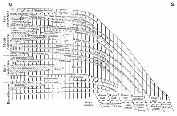
Fig. 2.1 Principal paleogeographic components of the Quaternary on the
East European plain. Compiled by A. Velichko
These natural processes and phenomena of the past strongly influenced various aspects
of the environment. The vast ice sheets altered topography, which was also affected by
glacioisostasy. Drainage systems were restructured due to ice damming and melt water. Vast
areas of the continental shelves were exposed due to the glacioeustatic fluctuations of
sea level (Alekseev, 1992). Some marginal seas temporarily lost their connection with the
world ocean while inner water bodies experienced fluctuations in water level and area
(Chepalyga, 1984).
<<< Climatic Change and the Development of
Landscapes | Physical Geography Index | Cryogenic Phenomena: Glaciations >>>
|


