Please put an active hyperlink to our site (www.rusnature.info) when you copy the materials from this page
Physical Geography of Northern Eurasia
Climatic Change and the Development of Landscapes
The Development of the Hydrographic Network of Northern Eurasia
<<< The Pre-Quaternary development of the
Drainage Network | Physical Geography Index | The Evolution of Areas of Internal Drainage >>>
The Evolution of River Valleys in the Glaciated and Periglacial
Regions in the Quaternary
At the beginning of the Quaternary, the outlines of the drainage network on the plains
were similar to the modern ones. Intervals of more active incision (e.g., the early
Pleistocene on the East European plain) did not change the valley pattern significantly.
Important changes in drainage systems on the plains were associated with the continental
ice sheets. In glaciated areas, drainage ceased. Some of the preglacial valleys were
filled with till and were not restored after the ice sheet had retreated. At the margins
of the ice sheet, ice-dammed lakes formed. The positions of the lakes changed as they
followed the retreating glacier. In the ice-free areas, runoff and sediment budgets
changed significantly due to the input of melt water and climatic change. Finally, ice
sheets left behind assemblages of hummocks and closed basins where the upper links of
drainage systems began developing. This process strongly affected sediment budgets in the
main valleys.
The way in which a glacier impacts a drainage network in the ice-free zone is
controlled by the position of the marginal zone with respect to main water divides, the
general gradient of the surface and other factors. If the ice sheet moves downslope, the
melt water runoff occurs in the existing channels, which have greatly enlarged zones of
alluviation such as, for example, the prominent terraces of the Volga, Dnieper, Don, and
their tributaries dated to the middle of the Quaternary. Valleys following the ice margin
(similar to Urstromtaler of Western Europe) seldom occur on the East European plain. The
preglacial valley network was sufficiently dense to allow melt water to pass through
without the formation of new channels. A rare exception is an ancient valley, which
followed the eastern margin of the Dnieper ice lobe being positioned across the modern
valleys of the left tributaries of the Dnieper.
Glacial impact on the drainage system in Western Siberia is a more complicated issue.
In the north, most of the large valleys are of pre-Quaternary age. However, the presence
of the middle Pleistocene till as far south as 69°N has led to the idea that a gigantic
ice-dammed basin existed, covering much of the plain and overflowing south-westward
through the Turgai trough. Similar ideas have emerged with respect to the late Pleistocene
Zyryanka glaciation (Arkhipov et al, 1993). However, geological evidence from the Turgai
trough does not support this hypothesis. As early as the 1950s, it was found that there is
no trace of Ob and Yenisey water flowing into the Aral basin (Yanshin, 1953). Another
hypothesis suggests that glaciers, which expanded onto the West Siberian plain from the
west and the east, did not merge and never blocked the north-flowing rivers completely
(Olyunin, 1993). Lakes developed locally in the valleys of the Ob, Yenisey, and their
tributaries. They were not large and possibly developed seasonally. There might be local
changes in drainage patterns. For example, ice, which descended from the Putorana plateau,
made the Yenisey shift westwards. This hypothesis is in better agreement with geological
data.
The drainage system acquired its modern pattern during the late Pleistocene climatic
macrocycle. Its beginning, which corresponded to the Mikulino-Kazantsevo inter-glacial,
was marked by the Boreal marine transgression when the sea entered river valleys without
affecting the valley pattern. The subsequent glaciation was less extensive than the
earlier ones. On the East European plain, the ice sheet did not expand outside the Baltic
and the Arctic basins and only during its maximum expansion did melt water flow through
the upper Dnieper and upper Volga valleys as indicated by the valley trains (Meshcheryakov
and Aseev, 1974). Relatively widespread were proglacial lakes because the general
northward surface slope prevented melt water from flowing southwards. Some of these lakes
overflowed into the upper Volga drainage system. As the ice sheet retreated, the lakes
also shifted, leaving an intricate system of lacustrine terraces. Ice-dammed lakes may
also have existed in the basins of the Ob and the Yenisey, although their size is
debatable. Presumably, there was an overspill of such a lake from the Yenisey system into
the Ob system. The flow of the Lena did not cease, although at the maximum phase of
glaciation the river channel was forced westwards by the piedmont glaciers.
During the last Pleistocene pleniglacial, most Siberian rivers continued onto the then
emerged shelf where their submerged valleys still can be traced (Pavlidis et al., 1997)
(Figure 2.4).
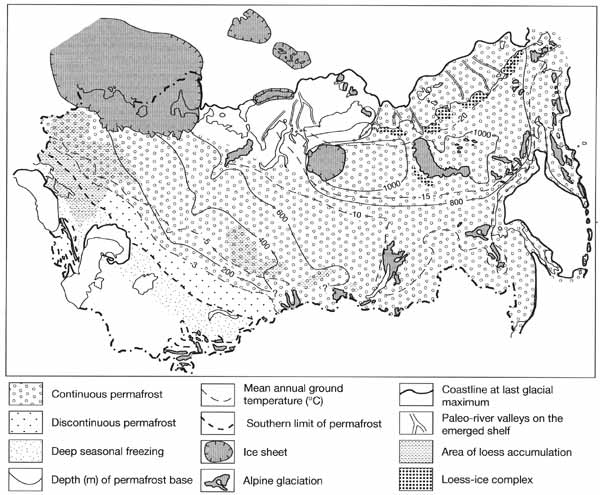
Fig. 2.4 Glacial and periglacial areas during the late Pleistocene
glacial maximum (20-18 Ka BP). Modified from Velichko (1984) and Pavlidis et al. (1997)
<<< The Pre-Quaternary development of the
Drainage Network | Physical Geography Index | The Evolution of Areas of Internal Drainage >>>
|


