Please put an active hyperlink to our site (www.rusnature.info) when you copy the materials from this page
Physical Geography of Northern Eurasia
Biodiversity and Productivity of Ecosystems
<<< Biodiversity: Definition and
Functions | Physical Geography Index | Geography of Diversity of Plant Communities >>>
Biomes of Northern Eurasia and Climate
Both Western (Walter, 1980) and Russian (Isakov and Panfilov, 1984) biogeographers
define a biome as a major climatically controlled biotic community. Vegetation is the most
indicative characteristic of biomes. It is in a plant community that continuous energy
flow and cycling of nutrients occur. Vegetation also provides habitats for heterotrophic
organisms, such as animals, bacteria, and fungi.
Nine major biomes and ecotones can be distinguished in Northern Eurasia (Figure 7.2):
polar deserts, tundra (including arctic, typical, and southern tundra), forest-tundra,
taiga (or boreal coniferous forest, including northern, middle, and southern taiga),
broad-leaved forest (including mixed broad-leaved coniferous forest), forest-steppe
(including broad-leaved forest and meadow steppe), steppe (including true and dry steppe),
semi-desert, and desert.
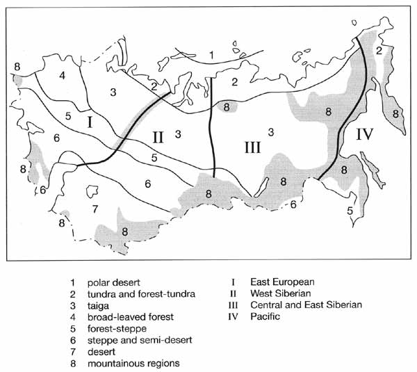
Fig. 7.2 Major biomes and biotic sectors
Mountains differ climatically from the surrounding plains and are considered separately
as orobiomes (Walter, 1980). In comparison with 60 units of Sochava's (1964)
classification of vegetation, this is a generalized scheme which is intimately linked to
thermal and moisture characteristics of the territory (Figures 7.3 and 7.4). Apart from
the biomes, four major biotic sectors are distinguished, East European, West Siberian,
Central and East Siberian, and Pacific.
The development of a biome depends on characteristics of the physical environment,
especially climate. A comparison of the patterns of biome distribution (Figure 7.2) with
the patterns of net solar radiation (Figure 7.3) and the rate of evaporation (Figure 7.4),
reveals a close match between biome distribution on the one hand and heat and moisture
availability on the other.
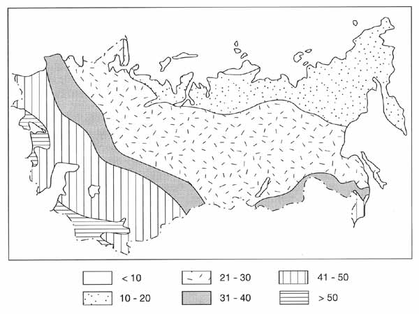
Fig. 7.3 Mean annual budget of solar radiation (kcal cm-2 a-1)
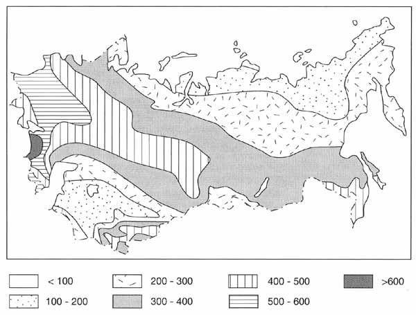
Fig. 7.4 Annual evaporation (mm)
Strong dependence of biome distribution on climatic factors in Northern Eurasia may be
demonstrated by introducing a concept 'climatic areas', suggested by Grebenschikov (1974)
originally in relation to the vegetation of the Caucasus and later used in climatic
ordination of vegetation of the FSU (Bazilevich et al., 1986). [Grebenschikov (1974) used
the approach of Walter (1955) who introduced ecological climate diagrams into
biogeographical analysis. The Climate Diagram World Atlas (Walter and Leith, 1967)
contains over 8000 climate diagrams for various locations in the world].
This approach uses two climatic factors: the annual sum of air temperatures for the
days when it exceeds 10°C and the annual amount of precipitation. By combining these two
factors, heat supply to plants and the effectiveness of precipitation are evaluated. This
approach, therefore, provides more relevant information from the ecological standpoint
than analysis of annual temperatures (which encompass an entire variety of monthly
averages and extreme values) or precipitation (whose effectiveness depends on
evaporation).
Figure 7.5a provides an example of the major climatic areas and illustrates climatic
conditions which are optimal for the development of major biomes.
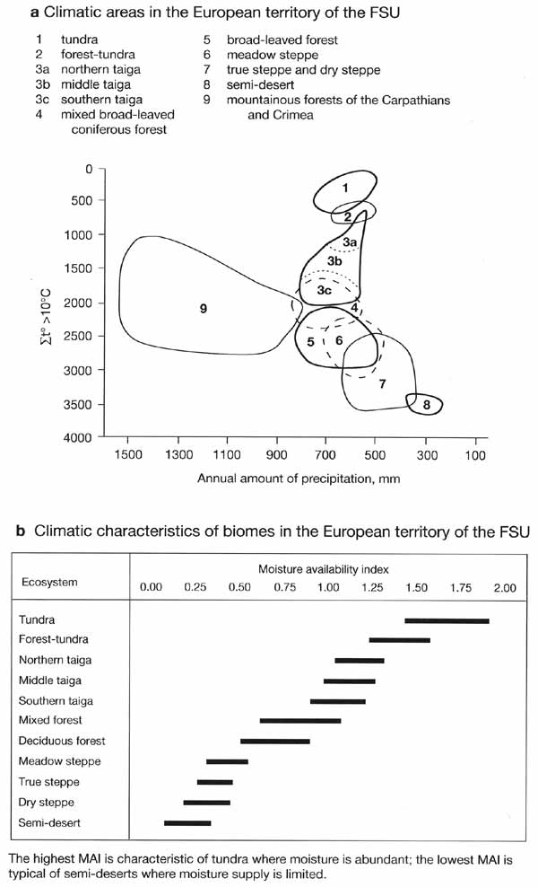
Fig. 7.5 Climatic areas and climatic characteristics of biomes. After
Bazilevich et al. (1986)
Thus climatic conditions, favouring the development of forest ecosystems on plains are
characterized by: (1) the annual sums of air temperatures exceeding 10°C ranging between
1500°C and 3000°C; and (2) the annual precipitation totals ranging between 600 mm and
900 mm. The tundra biome receives less precipitation and a much more limited amount of
heat. Thermal resources of the arid biomes of the East European steppes and semi-deserts
are high, while the amount of precipitation is limited. The areas of mountainous
ecosystems in Eastern Europe (the Carpathians, Caucasus, and Urals) receive a high amount
of moisture and a relatively low supply of heat.
A useful index, illustrating climatic controls over the development of vegetation, is a
moisture availability index (MAI) which also incorporates both moisture and heat factors:
MAI = P/E (7.1)
E = 0.2 (Sum t) + 306 (7.2)
where P is the annual amount of precipitation (mm), E is potential evaporation (mm),
and t are temperatures exceeding 10°C. Figure 7.5b shows the distribution of the same
biomes as in Figure 7.5 a with respect to MAI. Note that although tundra receives average
amount of precipitation, it is characterized by the highest moisture availability due to
the very low evaporation rates. This is one of the factors controlling the widespread
development of wetlands in the tundra biome.
In the European territory, biomes generally follow a zonal (latitudinal) pattern
(Figure 7.2).
Fig. 7.2 Major biomes and biotic sectors
In Siberia, where continentality of climate is a major control, and in the Pacific
sector, which is influenced by the ocean, the latitudinal distribution of ecosystems is
less well pronounced.
Not only are the extent and nature of biomes of Northern Eurasia determined by climate,
but the location of biomes and of correlated climatic indices result from the interaction
in which vegetation and climate affect each other. For example, the current northern and
southern boundaries of the boreal forest approximately correspond to the location of the
July 13°C and 18°C isotherms. Modelling has shown that if in the future extensive
deforestation occurs due to, for example, over-logging, it can cause a cooling of climate
sufficient to prevent forest regrowth in much of the deforested area (Bonan et al., 1992).
Thus, boreal deforestation may initiate a long-term irreversible feedback in which the
forest does not recover and the tree line moves progressively south.
<<< Biodiversity: Definition and
Functions | Physical Geography Index | Geography of Diversity of Plant Communities >>>
|


