Please put an active hyperlink to our site (www.rusnature.info) when you copy the materials from this page
Biomes and Regions of Northern Eurasia
Lake Baikal
<<< Introduction | Biomes & Regions Index | Hydrology of Lake
Baikal >>>
Geophysical Features of Lake Baikal and its Catchment
Lake Baikal is situated in one of a series of rift zones, that began to form over 30
million years ago during the Tertiary (Belova et al, 1983). Although the lake has changed
shape considerably through geological time, it is thought to be by far the oldest lake in
the world. Geological timing of the formation of all basins, and their subsequent
deepening is still under debate and is reviewed in Kozhova and Izmesteva (1998). Today,
Baikal occupies the world's deepest continental depression, at 1164 m below sea level and
is made up of three large basins (graben) of differing ages (Kozhov, 1963; Figure 17.1).
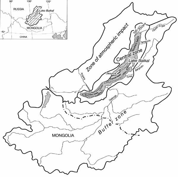
Fig. 17.1 Location of Lake Baikal and major tributaries used to gauge
solute budgets
The basins are separated by two underwater highs: the Selenga Shallows in the south,
and the Academician Ridge in the north. The rift valley is currently expanding at a rate
of c. 2 cm a-1, and is associated with intense seismic activity (SB-RAS, 1996).
Only c. 140 years ago, over 200 km2 of land sank below the water surface,
forming what is now known as Proval Bay, near the Selenga delta (Galazii, 1991). Lake
Baikal itself is surrounded to the east and west by large, steeply sloping mountain ranges
(horsts), broken only occasionally by valleys and deltas. These belong to some of the
larger rivers, such as the Selenga and Upper Angara, whilst others are preserved from, for
example, Pleistocene events.
Although in area Lake Baikal is only the seventh largest fresh-water lake in the world,
its great depth means that it contains the largest volume of surface fresh water (23 015
km3) (Kozhov, 1963). A total of 365 rivers flow into Baikal, and there is only
one outflow, the Angara in the south basin. The largest inflow is the Selenga that has its
source in the Mongolian highlands; this delivers just less than 50 per cent of all water
to the lake. General morphological physical characteristics of the lake are summarized in
Table 17.1 (Kolokoltseva, 1968).
Table 17.1 Morphological characteristics of Lake Baikal
The physical catchment of Lake Baikal occupies an area of c. 540 000 km2,
spanning south-eastern Siberia and northern Mongolia (Kozhov, 1963). Over the last two
decades, however, an area known as the 'Lake Baikal Region', has expanded to include
specified regions outside the immediate catchment area, that are recognized as having a
direct influence on catchment properties, for example, through pollution (SB-RAS, 1996)
(Figure 17.1). The Region is thus defined by both its physical and political-economic
geographies. This regional designation has in turn had an important impact in controlling
development around the lake, and has been crucial in the lake obtaining its World Heritage
Site status. These zones comprise the following (SB-RAS, 1996):
- 1. The central zone, which includes the lake and natural parks and reserves around the
lake.
- 2. The buffer zone, which includes the rest of the physical catchment area both within
Russia and Mongolia.
- 3. The zone of atmospheric impact, which occupies an area immediately outside the
physical catchment area to the west and north-west of the lake.
The Lake Baikal Region exists at the junction between several biogeographically
distinct regions (i.e., Central Asian, eastern Asian, and European-Siberian, consisting of
combinations of taiga, tundra, steppe and high mountainous deserts), and consequently has
extremely diverse communities of plants and animals (Kozhova and Izmesteva, 1998). Over
2500 vascular plants can be found in the Lake Baikal Region, of which it is estimated
about 10 per cent are endemic (SB-RAS, 1996). Major regions of vegetation immediately
surrounding the lake are shown in Figure 17.2.
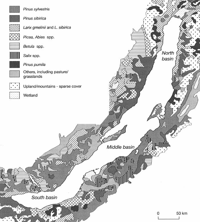
Fig. 17.2 Major vegetation zones within the central zone of the Baikal
Lake area. Modified from Atlas Baikala (1993)
Taiga forests are dominated by pine (Pinus sylvestris), larch (Larix sibirica), cedar
(Pious sibirica), and fir (Abies sibirica), together with an understorey of various shrubs
and grasses. Steppe vegetation is characteristic of the dry Mongolian steppes, often
showing a degree of desertification. In the highland zones tundra predominates, although
peat is common in depressions and highland plateaux. Near the lake shore, terraces in the
north support Larix gmelinii and Rhododendron dahuricum, whilst in other regions extensive
areas have been cleared of trees and summer dwelling has proliferated in recent years.
Subsistence agriculture is commonly practised by numerous small communities on the shores
on parts of the southern and middle basins. The eastern shore of the northern basin is
least populated and here dense woodland extends to the lake shore, especially Pinus pumila
and Betula ďŕďŕ.
Local terrestrial faunal populations are even more diverse and include some 90 species
of mammal, 400 bird species, 20 species of reptiles and amphibians and, what is certainly
an underestimate, 5000 species of invertebrates, especially insects and spiders (SB-RAS,
1996). Endemism is particularly common in the Baikal mountains, which also serve to act as
a boundary between western and eastern species. Interestingly, lakes other than Baikal
within the Lake Baikal Region, contain an impoverished fauna (e.g., fish and
invertebrates), perhaps because of past and present severe climate conditions (Kozhova and
Izmesteva, 1998). On the other hand, many of these lakes contain relict animal species
(Kozhov, 1963) and plants, including algae (Flower et al., 1998).
<<< Introduction | Biomes & Regions Index | Hydrology of Lake
Baikal >>>
Contents of the Lake Baikal section:
Other sections of Biomes & Regions:
|
|


