Please put an active hyperlink to our site (www.rusnature.info) when you copy the materials from this page
Biomes and Regions of Northern Eurasia
The Far East
<<< Sakhalin | Biomes
& Regions Index | The Kuril Islands >>>
Kamchatka
Kamchatka is the largest of Russia's peninsulas and extends for about 1200 km in a
meridional direction. Four major structures are distinguished within the region (including
the nearby islands): the Koryak and Olyutor-Kamchatka systems which form the
Koryak-Kamchatka fold belt extending between the Okhotsk-Chukotka volcanic belt and the
Pacific; the Kuril-Kamchatka island arc extending from Cape Lopatka (the southernmost tip
of Kamchatka) to Hokkaido; and the Komandorskiye islands which form the western segment of
the Aleutian island arc (Zonenshain et al., 1990). The most distinguishing feature is high
seismic activity and contemporary volcanism: there are 28 active and over 150 extinct
volcanoes in Kamchatka and 39 active volcanoes in the Kurils (Deistvuyushie vulkany
Kamchatka, 1991; Kozhemyaka, 1994). These are connected to the sub-duction of the Pacific
Plate along the Kuril-Kamchatka trench which is situated about 150 km from the volcanic
front. Neotectonics and active volcanism are the two major factors shaping the landscapes
of Kamchatka. The Pleistocene glaciations, controlled in turn by global climate change and
the ongoing building of the mountains, are another important factor.
Structural-lithological complexes within the Koryak-Kamchatka fold belt become
successively younger from west to east: while in the Koryak system folding ceased in the
late Cretaceous, in the Olyutor-Kamchatka system it continued until the Oligocene-Miocene
boundary while the peninsulas of eastern Kamchatka and the Karginsky islands joined
Kamchatka in the middle Miocene. The Olyutor-Kamchatka system is mainly composed of the
remnants of two island arcs of late Cretaceous and Paleogene age which collided with the
margin of Eurasia prior to the Oligocene, while in eastern Kamchatka island-arc volcanism
continued through the Oligocene and the early Miocene, with the terrains (e.g., the
Kronotsky and Kamchatsky Cape terrains) being brought to the subduction zone and accreted
(Zonenshain et al., 1990; Pushcharovsky and Melanholina, 1992). Most active volcanoes
occur in the east, extending from the Shiveluch volcano (56°47'N) to the southernmost
extremity of the peninsula (Figure 18.5). The active volcanoes of Kamchatka are
geologically very young with maximum ages of about 50-40 Ka (Braitseva et al., 1995a, b).
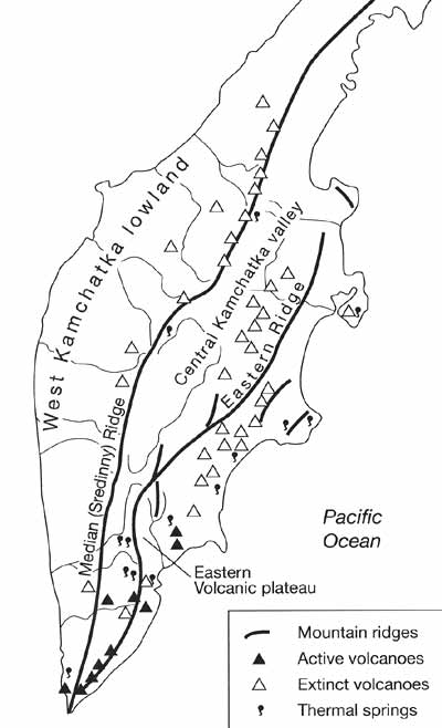
Fig. 18.5 A sketch map of Kamchatka
Morphological Regions and Environmental History
Five distinct morphological regions extending in a sub-meridional direction are
distinguished within Kamchatka (Figure 18.5): the West Kamchatka lowland, the Median
(Sredinny) Ridge, the Central Kamchatka valley, the Eastern Ridge, and the Eastern
Volcanic plateau (Luchinsky, 1974).
The western 80-100 km wide coastal lowland is formed by the thick strata of Cenozoic
continental deposits. The coastal zone comprises a number of sandy-clay marine terraces
and low and level accumulative plains which are weakly dissected by wide and shallow river
valleys. Blanket bogs are widespread on the lowland forming an almost continuous strip
along the coastline. The peat is about 3 m thick and locally peat deposits are large
enough to be of commercial value. Further inland, the lowland rises gently to the foot of
the Median Ridge becoming progressively better drained and less bogged.
The Median Ridge consists of separate ridges and volcanic plateaux with prevailing
heights of 1200-1500 m. The ridge has an asymmetrical structure: its western macroslope is
gentle while the eastern macro-slope, limited by the Central Kamchatka graben, is very
steep. Tectonically, the Median Ridge massif is a continental fragment which collided with
the Olyutor arc at the end of the late Cretaceous and which is now overlain by
allochthonous cherts and volcanic complexes of the Olytor-Kamchatka system (Shapiro et
al., 1986). The northern part of the ridge is formed mainly by volcanic rocks: basalts,
tuffs, and andesites of Maastrichtian age. In other places, deep-water cherts and shales
prevail, intermingling with pillow basalts (Zonenshain et al, 1990). Volcanic activity in
the Median Ridge occurred mainly in pre-Quaternary time and at present low fumarole
activity is limited to its tallest volcano, the Ilchinskaya Sopka (3621 m). In the north,
volcanic relief combines with glacial and periglacial forms associated with the late
Pleistocene glaciation. Two glacial phases are distinguished although the sequence of
glaciation is still subject to controversy (Ananyev et al., 1993). Although moraines,
till, and fluvio-glacial deposits of the earlier phase are poorly preserved, the extent of
their distribution testifies to the extensive nature of the first phase. In the northern
part of the Median Ridge, glaciation was of a reticulated type while in other regions it
was of a mountain valley nature and only locally did valley glaciers descend into the
foothills. Landiorms (e.g., end moraines, kames, and roches moutonnees) associated with
the later phase are better preserved. The status of the two glacial events and the nature
of the warm interval are still debated because of a notable lack of dates for sediments of
the warm interval. Pollen analysis has shown that Betula-Larix forests with an admixture
of Picea developed between 39 and 31 Ka BP on the West Kamchatka lowland pointing at a
warmer climate than now (Noveishie otlozheniya, 1978). However, the biotic history of the
late Pleistocene warm interval has been poorly studied and requires further investigation.
The age of the second phase has been reliably established as between 21 and 10 Ka BP from
sediments collected in the foothills of the Klyuchevsky volcanic massif (Kraevaya et al.,
1983). Skeletal remains of mammoth found immediately under the till layer pointed at the
lower boundary while a relict soil layer overlaying the till and buried under pyroclastic
sediments indicated the beginning of the interglacial. The second phase of the late
Pleistocene glaciation in Kamchatka may be correlated with the late Valday glaciation on
the East European plain and the Sartan glaciation in Siberia. Although glaciation was
extensive, its type and spatial extent were controlled by the distribution of
precipitation (which is in turn controlled by topography) rather than absolute height.
This resulted in a non-uniform distribution of the ice. The northern Median Ridge was the
most extensively glaciated region in Kamchatka. In the northern part of the eastern
macroslope, open to the moisture-laiden flow, only few watersheds were free of ice which
descended on to the then exposed shelf forming a piedmont glacier. By contrast, south of
the Shiveluch volcano, where the penetration of the easterly flow is limited by the
Eastern Ridge, glaciation was markedly less extensive. Over 50 per cent of the modern ice
of Kamchatka, which in total occupies 870 km2, is concentrated in the northern
Median Ridge. The snow line has a low position (about 1000 m a.s.l.) as a result of high
humidity and cool summers. Glaciers usually cap the tallest summits, descending from the
top in several streams which give the glaciers a characteristic star-like shape. Similar
to many other regions, the Kamchatka glaciers are currently in a stage of retreat. Studies
of glaciers of the volcanoes of the Tolbachic, Klyuchevsky, and Avachinsky groups (Central
Kamchatka valley and the Eastern Volcanic plateau) have shown that the modern position of
the termini is 100-200 m above those observed during the periods of maximum glacial
advance in the 1690s, 1850-70 and 1910-20 (Solomina et al., 1995). Volcanic activity has
short-term effects on glacial regime: not only does ice melt because of the volcanic heat
but short-term advances also occur due to the low atmospheric transparency and lower
temperatures that follow volcanic eruptions (Solomina et al., 1995).
The Central Kamchatka valley is a 50-80 km wide graben that separates the Median Ridge
and the Eastern Ridge. The valley is constricted by the two ridges in the south, widening
to the north where its relief becomes almost level. It contains the largest river of the
peninsula, the Kamchatka (720 km in length). It was a water basin as recently as the early
Pleistocene and at present it is predominantly filled with Cenozoic marine deposits
overlain by thick layers of Quaternary and modern andesitic and basaltic lavas as well as
fluvioglacial and alluvial sediments. The main centres of the Pleistocene glaciations were
the Shiveluch volcano and volcanoes of the Klyuchevsky and Tolbachik groups. Their slopes
were covered with ice which descended well into the valley and vast fluvioglacial plains
were formed on ice retreat. The alluvial plains and terraces of the Kamchatka are of a
younger Holocene age.
The average elevations in the Eastern Ridge, extending from the south of the peninsula
to the Ozerny Bay, are about 1300-1500 m and its highest point is the Kizimen Volcano
(2485 m). The ridge has a complex accretional structure comprising three main tectonic
units and its topography is formed by a number of ridges and volcanic plateaus. The core
of the ridge is formed by Cretaceous rocks, and the spurs are composed pf Paleogene
sandy-shales and volcanic rocks. Across vast areas, bedrocks are overlain by thick
Quaternary andesitic and basaltic lavas. Evidence of late Pleistocene glaciation is
widespread and indicates that glaciers descended into the sea. Contemporary glaciation is
mainly limited to the Kronotsky peninsula where glaciers descend from Mount Otdelnaya to
an altitude of 500 m a.s.l.
The Eastern Volcanic plateau is a 700-900 m high hilly terrain with volcanic cones set
upon it. Out of 28 active volcanoes of Kamchatka, 22 are located here. The plateau is
formed by pyroclastic material: thick deposits of lava, tuff, volcanic sand, and ash. In
the late Pleistocene, volcanoes of the Avachinsky group as well as the mountains in the
upper portion of the Avach river were extensively glaciated. Another centre of glaciation
was located further south: the calderas of the Gorely and Ksudach as well as the Pauzhetsk
depression were filled with ice which descended along the valleys, forming large valley
glaciers. At present, the snow line is positioned at about 1500-1600 m. Summits of many
volcanoes are covered with snow while calderas are often filled with ice.
Volcanism as a Landscape-forming Factor
Active volcanism is one of the major factors that sculptures the landscapes of
Kamchatka (Plate 18.1), which is mainly formed by volcanic rocks such as andesites,
basalts, and tuffs.
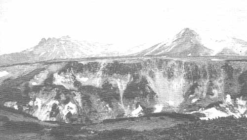
Plate 18.1 Volcanoes of Kamchatka
The volume of eruption products generated over the last 200 000 years totals 4200 km3
with the Quaternary effusives covering 42 per cent of the peninsula and landforms of
volcanic origin (e.g., lava plateaux, volcanic cones, ancient calderas, and volcanic
ridges) dominating its relief (Deistvuyushie vulkany Kamchatki, 1991; Kozhemyaka, 1994).
Research into the history of volcanism began in Kamchatka in the 1960s when new
techniques, including radiocarbon dating and tephrochronology, were developed. At present
a detailed account of the ages of most calderas, large explosive craters, and recently
active volcanoes is available largely through the work by Melekestsev and Braitseva of the
Institute of Volcanic Geology and Geochemistry in Petropavlovsk Kamchatsky. Holocene
volcanic activity is the best researched while information on pre-Holocene eruptions is
more limited. This is because the pre-Holocene soil, peat, and pyroclastic layers were
largely destroyed both in Kamchatka and the Kuril islands during the late Pleistocene
glaciation, while deposits accumulated under cold conditions are extremely poor in organic
matter. Potassium-argon dating is of limited utility due to the low concentrations of
potassium in the Kuril-Kamchatka rocks (Braitseva et al, 1995b). A number of periods of
enhanced volcanism occurred in the Quaternary with the intensity and scale of events
declining from the late Pleistocene to the present (Melekestsev et al., 1988). A period of
catastrophic volcanic eruptions occurred in the late Pleistocene, between 45-39 and 30-25
Ka BP, when the character of volcanism varied across the region. Acid volcanism dominated
in southern and eastern Kamchatka where the Kuril Lake, Opala, Gorely, Krashenninikov and
Uzon and Bolshoy and Maly Semyachik calderas and the surrounding ignimbrite and pumice
strata were formed, respectively, about 39-42 and 25-30 Ka BP (Braitseva et al., 1995a,
b). By contrast, basaltic volcanism dominated the Median Ridge, being also notable on the
Eastern Volcanic plateau (e.g., in the Kluchevsky and Avachinsky groups). Thick
tephra-rich layers, dated to the late Pleistocene, and found in the bottom sediments in
the north-western Pacific at a distance of 1000 km off the eastern Kamchatka coast and
near the city of Magadan, testify to the intensity of the eruptions (Melekestsev et al.,
1991). Volcanic eruptions were an important source of sediment accumulating in the Central
Kamchatka valley. The strata of loamy sands, reaching 40-50 m in thickness, are formed
largely of weathered pyroclastic material and contain numerous layers of tephra. The rate
of sedimentation was extremely high reaching 1-3 m per 1000 years, partly due to the large
amount of pyroclastics and partly to the high erosion rates resulting from the continuing
uplift of the mountains. Another period of enhanced volcanic activity followed in the
early Holocene between 9.5 and 7 Ka BP. According to Melekestsev et al. (1988), volcanism
of this period was weaker than during the preceding ones as indicated by a smaller amount
of pyroclastics, the formation of smaller calderas, and a notable lack of ignimbrites.
However, a paroxism of explosive acid volcanism between 7.8 and 7.5 Ka BP produced some of
the major acidity peaks in the Greenland ice cores and may have contributed to climatic
cooling (Zielinski et al., 1994). One more period of synchronous upsurge of volcanic
activity was 1800-1300 years ago. Several powerful explosive eruptions of the Shiveluch
took place, basalts started to erupt in the Tolbachik region and several stratovolcanoes
began to form (Braitseva et al., 1995a, b). While the activity of volcanoes of late
Pleistocene age is diminishing, those that started to form at the end of the late
Pleistocene and in the Holocene have remained extremely active. At present, almost the
entire territory of Kamchatka is affected by the fallout of volcanic material which are
most intensive in the east and in the south. Ashfalls periodically interrupt the
soil-forming process and widespread in Kamchatka are stratified ochre volcanic soils.
Ashfalls have a fertilizing effect and improve drainage. Rich vegetation, otherwise not
typical of the region, often develops on volcanic soils despite the severe climate
(Sokolov, 1973; Manko and Sidelnikov, 1989).
The widespread occurrence of porous volcanic rocks preconditions the efficient
infiltration of precipitation and the development of extensive underground drainage.
Spring floods are rare and occur mainly when enough volcanic ash is precipitated to cause
an exceptionally rapid thawing of snow. Widespread are lakes of volcanic origin which
either develop in the old volcanic craters or are formed by lava dams. These differ in
size, depth, temperature, and chemical composition. The two largest lakes, Kronotskoe (212
km2, 148 m in depth) and Kuril (76 km2; 306 m) are old volcanic
craters filled with water. Situated near active volcanoes of the Kronotskaya Sopka (3528
m) and the Ilchinskaya Sopka (1578 m), they are fed by numerous mountainous streams
originating in hot springs and despite cold winters some outlets of the lakes do not
freeze over.
The largest volcanic centre is the Klyuchevsky volcanic massif which comprises 20
volcanic formations and is of a young age (about 800 Ka BP). The massif occupies an area
of 7500 km2 with the total volume of volcanic rocks of about 8000 km3.
Volcanism is more intense than anywhere else in the region: on average, pyroclastic
material is generated at a rate of about 0.01 km3a-1 (Kozhemyaka,
1995). The tallest and one of the most active volcanoes of Kamchatka, the Klyuchevskaya
Sopka (4750 m), belongs to the massif. The Klychevskaya Sopka is glaciated, with a vast
glacier descending to a height of 1500 m along the eastern slope. Typical of the glacier
are alternating layers of ice, volcanic ash, and debris. The main features of the local
landscape are ice, young lava streams, and scoria-ash deserts. Other volcanic cones on the
Pacific side of Kamchatka (e.g., the Shiveluch) carry glaciers. However, volcanic activity
brings about the rapid melting of snow and while Kamchatka would seem to have conditions
ideal for the development of glaciers, relatively little snow and ice accumulate annually
except in the craters of extinct volcanoes. Volcanic and fumarole activity changes glacial
topography and rearranges the distribution of ice and often glaciers do not have permanent
channels. Volcanic ash, accumulating on the surface of the glaciers, changes their
radiation balance, promoting melting.
More than 150 groups of hot springs are known in Kamchatka (Gidrotermalnye sistemy,
1976). These are concentrated mainly in the Eastern Volcanic plateau and correspond to
centres of acidic volcanism which developed here in the late Pleistocene. The largest
formation is the Uzon-Geyser tectonic-volcanic depression which represents an oval-shaped
caldera, 15 km x 7.5 km. Water temperatures in thermal springs and lakes range between
38°C and 97°C. The largest in the Kamchatka geothermal power system with the combined
heat flow of 140 000 kcal s-1 is maintained by the Uzon-Geyser. Not only does
the strato-volcano Uzon formed about 40 Ka BP have a large caldera, but it is also
characterized by a unique variety of geothermal features including fumaroles, thermal
mineral springs, lakes, mud kettles, and mini-mud volcanoes. Lakes occupy craters reaching
100-150 m in diameter and 45 m in depth and water temperatures near the bottom of such
lakes may reach 130°C. In all, over 500 various geothermal features are found in this
relatively small area (Belousov et al., 1983). Under the geothermal conditions, rocks
transform into speckled clays. The ongoing formation of ores occurs near the discharge
centres of mineral thermal waters enriched with arsenic, zinc, copper, antimony, and
mercury (Karpov, 1988).
Another remarkable place is the Geyser Valley which, as its name suggests, has a high
concentration of geysers (19 geysers and 9 pulsing thermal springs occur across a 5 km
distance). The Geyser Valley is associated with a system of faults and fissures which
reach deep hydrothermal aquifers (Goleva, 1993; Ivanov et al., 1995) (Figure 18.6).
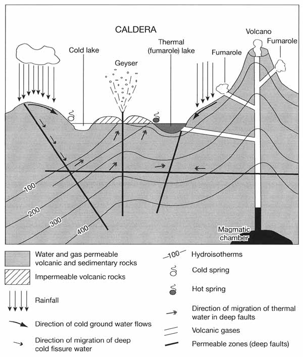
Fig. 18.6 Model of a hydrothermal system
The largest geyser, the Velikan (which name means 'a giant') has a pipe of 3 x 1.5 m.
Spouts of boiling water reach 35m while vapour is ejected to a height of 250 m. Not only
spouting geysers but also pulsing thermal springs, vapour jet sources, and mud geysers
occur in the valley. Depending on the thermal water discharge regime which varies in time,
geysers can act as pulsating springs and vice versa (Sugrobov and Sugrobova, 1990). Under
the influence of boiling water and vapour enriched with various mineral elements the
original rocks are transformed into geyserites (or sinters).
Ecology
Although the isolation of Kamchatka should have resulted in a strongly endemic biota,
its flora and fauna are neither original nor rich, first, because of the severe climatic
conditions, and second, because of the frequent catastrophic volcanic eruptions. There are
only 900 species of higher plants represented mainly by a circumpolar flora. For
comparison, there are about 2000 species in the Ural mountains and 6000 species in the
Caucasus which occupy approximately the same territory (Makunina, 1969).
The large extent of Kamchatka from north to south results in latitudinal zonation.
However, this is complicated by complex terrain and vertical differentiation is prominent
in the vegetation structure. About 30 per cent of the peninsula is forested and another 30
per cent is covered by Finns pumila and Alnus kamtschatica thickets, while the rest is
swamped or occupied by alpine tundra and volcanic landscapes. A vast tundra plain occurs
in the extreme north of Kamchatka and on the western coastal plain tundra communities
reach the southernmost extremity of the peninsula (52°N). Here, oligotrophic sphagnum
bogs form a 30-50 km wide continuous belt.
The basic vertical vegetation sequence is simple: forests occupy the lowest 600-880 m;
Pinuspumila and Alnus kamtschatica thickets occur above, extending to an altitude of
900-1000 m to be succeeded by alpine meadows, mountain tundra, and volcanic landscapes
(Bykasov, 1985). However, the vertical distribution of vegetation strongly depends on
climate and because the climates of the eastern coast and the Central Kamchatka valley are
different, more specific models have been proposed for each of these regions. Thus,
typical of the Central Kamchatka valley, which has a relatively dry climate, are
coniferous forests of the taiga type in which Picea abies and Larix cajanderi are the main
forest-forming species (Efremov, 1973; Manko and Vorochilov, 1978). At an altitude of
300-350 m, these are succeeded by forests composed of Betula ermanii (rock birch) which
develops from the base to the thicket belt on the humid and windy eastern coast. The rock
birch forests are perhaps the most distinguishing feature of Kamchatka's vegetation.
Characteristic of such forests is a rich herbaceous tier dominated by Calamagrostis
langsdorffti. The river and forest meadows are typical and account for a high proportion
of the forest zone. These are dominated by tall grasses such as Filipendula kamtschatica,
Cacalia hastata, and Heracleum lanatum which reach heights of 3.5-4 m under conditions of
optimum moisture supply (Stepanova, 1985). Thickets of shrubs and small trees form a
distinct altitudinal belt. These always consist of one species of shrub, usually either
Pinus pumila (in sunnier and drier habitats) or Alnus kamtschatica (in shady and moist
sites) and less often Sorbus sambucifolia. Despite many tall summits, the subalpine and
alpine zones are limited in extent because of the narrowness of the mountain crests,
sharpness of volcanic cones, and the inability of volcanic debris to support vegetation.
The subalpine tall-grass meadows, dominated by Heracleum dulce, Lilium avenaceum, Aconitum
flschery, Iris setose, and Fritillaria kamtschatcensis, develop on flat watersheds and
gentle slopes. The alpine zone is represented by alpine meadow and heath tundra
communities. Alpine tundra communities develop in drier habitats such as those on steep
slopes or porous volcanic rocks (Nescha-taev and Chramkov, 1994). Typical of such habitats
are Rhododendron aureum, R. kamtschaticum, Salix polaris, Vaccinium vitis-idaea, and V.
uliginosum.
Very unusual communities of thermophilic plants develop in geothermal areas where the
soil surface temperature reaches 80-90°C. Only a very few plants can adapt to such
conditions including Ophioglossum thermale, Fimbristylis ochotensis, Lycopus uniflorus,
and Stachys baicalensis (Rassohina and Chernyagina, 1982).
A small but remarkable vegetation community is that of an Abies gracilis grove which
occupies an area of 20 hectares on the eastern coast (Neshataeva and Fet, 1994). Although
this grove was first described by Krasheninnikov who led the first geographical expedition
to Kamchatka in 1755, its origin is still disputed. It has been suggested that Abies
gracilis may be a Tertiary relict (Naumenko, 1984) while other hypotheses suggest that it
is a relatively young Holocene formation (Skiba, 1975) possibly planted by indigenous
tribes for worship (Turkov, 1967).
The fauna of Kamchatka resembles that of an island. Because the peninsula is separated
from the mainland by the treeless Parapolsky valley, there are no typical taiga species
(e.g., elk, musk deer, polecat, lynx). Brown bear is the most common species and the bears
of Kamchatka are among the largest, reaching a weight of 650-700 kg (Plate 18.2).
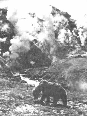
Plate 18.2 A brown bear in the Geyser Valley, Kamchatka
In the mid-1960s, their population reached 20 000 but it has been since reduced to
under 8000 (Gordienko and Radnaeva, 1994). There are no more than 200 bird species and no
reptiles.
Environmental Management and Nature Protection
Most of Kamchatka does not experience strong anthropogenic pressure. This is mainly
limited to two areas: the Petropavlovsk-Elizovo agglomeration where 80 per cent of
Kamchatka's industrial potential and 70 per cent of population are concentrated, and the
Central Kamchatka valley which has natural conditions suitable for commercial agriculture
and forestry. Although at present the cities of Kamchatka are far from being
pollution-free, maintaining high environmental quality in the future is feasible because
there is no need to burn fossil fuel. Geothermal resources guarantee virtually unlimited
supplies of energy. Thus, a geothermal power with a potential total capacity of 3 x 10s
watts spares the necessity of burning a million tonnes of coal per year (Karpov, 1994).
The first Pauzhetskaya geothermal power plant has been operating since 1967 and another
plant is currently under construction. It is not unusual for farmers to use geothermal
water.
The pristine condition of the environment offers great opportunities for the
development of ecotourism. There are a number of protected areas of different types which
account for 27 per cent of the total area (Santalov, 1995). In 1996, a network of
protected areas 'Volcanoes of Kamchatka' was included in the UNESCO list of World Nature
Heritage.
<<< Sakhalin | Biomes
& Regions Index | The Kuril Islands >>>
Contents of the Far East section:
Other sections of Biomes & Regions:
|
|


