Please put an active hyperlink to our site (www.rusnature.info) when you copy the materials from this page
Biomes and Regions of Northern Eurasia
The Mountains of Central Asia and Kazakhstan
<<< Environmental Change Since the Late Pleistocene
| Biomes & Regions Index | Mountainous Biota
>>>
Modern Glaciation
Most researchers agree that the contemporary glacia-tion in the mountains of Central
Asia and Kazakhstan is inherited from the preceding stage (Serebryanny, 1984). However,
the contemporary orography of the mountains (height and the transverse orientation of many
ridges) provides conditions for the accumulation of permanent snow and glaciers. The
position of the snow line is high in comparison with the other mounatinous regions of the
FSU because of the aridity of climate, high levels of insolation, and supply of heat from
the plains in summer. The altitude of the snow line generally increases from the
north-east and the north-west towards the arid inner regions of the Pamir. The lowest
position occurs on the northern slope of the Dzhungarsky Alatau (3000 m) and northern
Tien-Shan (3600 m), increasing to 4200 m in the central Tien-Shan and 5200 m in central
and eastern Pamir. Aspects strongly influence the position of the snow line. For example,
in the Terskey-Alatau the difference between the southern and the northern slopes reaches
600 m.
The mountains of Central Asia and Kazakhstan are the largest centre of alpine
glaciation in the FSU. The combined area of glaciers is approximately 16 000 km2,
which accounts for 70 per cent of the total area occupied by alpine glaciers in the FSU.
Glaciation has a sporadic pattern characterized by a few regions of glacier concentration
such as the Khan-Tengri massif in the central Tien-Shan, the Matchinsky massif where the
Zeravshansky, Alaysky, and Turkestan Ridges converge in north-western Pamir, the Zaalaysky
Ridge, and the junction of the Peter the First, Academy of Sciences, and Darvaz Ridges in
Badakhshan (Figure 16.7). The Fedchenko glacier (907 km2), the largest in the
FSU, is located in the latter centre whose tremendous extent is due to the interception of
moisture carried by the westerly flow by the transverse Academy of Sciences Ridge. In
total, the Pamir-Alay and Pamir accommodate about 9800 glaciers whose combined area
reaches 10 000 km2, accounting for more than 10 per cent of the total area.
Glaciers of the Pamir and Pamir-Alay are the single most important source of water for the
plains of Central Asia. Accumulated in the glaciers are 600 km1 of fresh water and about
13 km3 are delivered annually to the plains.
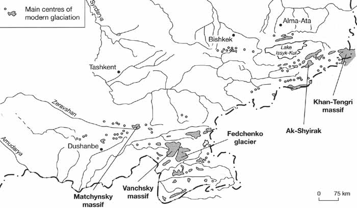
Fig. 16.7 Main centres of modern glaciation
Not only do glaciers occupy a vast area in the mountains of Central Asia and
Kazakhstan, but also a variety of glacier types occur and they have especially large
dimensions (Table 16.5).
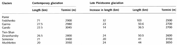
Table 16.5 Parameters of glaciers at present and in the Pleistocene
Depending on the environmental conditions cirque, hanging, valley, and plateau glaciers
develop. The vast and flat plateau glaciers, which do not occur anywhere else in the FSU,
develop on the highly elevated denuded surfaces and are particularly common in central
Tien-Shan. Because the plateau glaciers occupy watersheds, they receive little derrital
material and their moraines are poorly developed. The large branching valley glaciers
occur throughout the region. For example, the Fedchenko glacier receives thirty seven
tributaries, six of which are more than 10 km long, and the Inylchek glacier in the massif
Khan-Tengri receives thirty tributaries, some of which exceed 15 km in length. Typical of
the region are glaciers of a specific, so-called Turkestan, type which may be considered
as valley glaciers in the stage of decay. The firn area of such glaciers is
disproportion-ally small in comparison with the glacial tongue, their nourishment is
accomplished mainly by avalanches and they are covered by thick moraine (Fedorovich et
al., 1975). The abundance of rock material on the valley glaciers, of both the ordinary
alpine and Turkestan types, is due to the intense weathering controlled by strong
temperature fluctuations which can be as high as 90°C. The extent of glaciers and their
depth vary greatly. The largest glaciers are over 100 km long and their depth may exceed
500 m (e.g., the Fedchenko, Inylchek, Oktyabrsky). In general, large glaciers move at a
rate of about 80-100 cm day-1. However, the rate of movement depends on many environmental
factors and while the Inylchek moves at about 1200 m a-1, the Fedchenko glacier
is less dynamic and moves only 200-300 m a-1 (Fedorovich et al., 1975).
The Central Asian glaciers have been in decline since the end of the Little Ice Age.
Analysis of aerial photography has shown that in the Ak-Shyirak massif 147 glaciers (83
per cent) retreated, 24 (13 per cent) were stable, and 7 (4 per cent) advanced between
1934 and 1977 (Chaohai and Tianding, 1992). In the Zailiisky Alatau, glaciated area
decreased by 63.3 km2 between the mid-1950s and 1980. Since the 1970s, the
retreat rate declined in response to higher precipitation observed between 1961 and 1972.
In contrast to the Alps and the Caucasus, precipitation and summer temperature (which
controls melting) in the Central Asian mountains did not vary synchronously and the
decline was marginal especially in the eastern regions of the Tien-Shan where a summer
maximum in precipitation occurs.
Despite the recent tendency towards reduced retreat rates, long-term observations
indicate that glaciers, which are in equilibrium with their climatic environment, such as
for example, the Shumsky glacier in the Dzhungarsky Alatau, display trends towards slower
ice flow, more negative net balance, and faster rate of ice thinning (Cherkasov et al.,
1996). This points to the evolution of a climatic environment that is less conducive to
the maintenance of glaciers. Given the importance of alpine glaciers as sources of water
for the plains, this trend is alarming. Numerous attempts at forecasting glacial change
have been made. Thus according to Dikikh and Usubaliev (1996), in the future glaciers in
the Tien-Shan may disappear at an altitude of 4100-4300 m and below, while glaciation in
the Chu basin may decrease by 20 per cent. By 2020, glaciation may decline by 75-80 per
cent on the southern slope of the Kungey-Alatau and on the northern slope glacial
discharge may increase by 40-50 per cent due to the changing ratio between ablation and
accumulation (Dikikh and Usubaliev, 1996).
In the eastern Pamir and central Tien-Shan, discontinuous permafrost and cryogenic
relief forms occur widely at an altitude of about 3800 m. The extreme aridity of climate
(particularly in the eastern Pamir) and low moisture content of soil control a high
position of both the upper and lower boundaries of permafrost distribution, shifting it
500-800 m upwards in comparison with more humid environments (Gorbunov, 1990). Thus, in
the eastern Pamir, the altitudinal permafrost boundary is positioned about 500 m higher
than at the same latitude in the Qilan-Shan mountains which receive ten times more
precipitation. Due to soil moisture deficiency, large (several metres in dimension)
cryogenic forms of relief are rare and confined to the more humid localities. Cryogenic
microforms — solifluction micro-terraces, miniature sorted polygons, and stripes, etc.
— with dimensions of few centimetres are ubiquitous, giving slopes a characteristic
patterned appearance.
<<< Environmental Change Since the Late Pleistocene
| Biomes & Regions Index | Mountainous Biota
>>>
Contents of the Mountains of Central Asia and
Kazakhstan section:
Other sections of Biomes & Regions:
|
|


