Please put an active hyperlink to our site (www.rusnature.info) when you copy the materials from this page
Biomes and Regions of Northern Eurasia
The Mountains of Central Asia and Kazakhstan
<<< Contemporary Climate | Biomes & Regions Index | Modern Glaciation
>>>
Environmental Change Since the Late Pleistocene
Although much effort has been devoted to the reconstruction and interpretation of the
environmental history of the Central Asian mountains, the extent, sequence, and nature of
climatic and environmental change are still subject to controversy. One reason is the
complex nature of their evolution. Local environmental change was set against the
background of two major processes: (I) growth of the continental area, intensification of
the Siberian anticyclone, and the expansion of deserts which forced irreversible
aridization; and (II) the intense rise of the mountains which provided conditions for the
expansion of glaciation. The other reason is the incompleteness of the environmental
record. While research, encompassing geomorphological and loess studies, pollen analysis,
and radiocarbon dating, has been carried out extensively in the high altitude regions of
the Tien-Shan (in the Issyk-Kul basin in particular) and in the piedmonts of the
Pamir-Alay, other regions have not been sufficiently researched.
During the late Pleistocene, the Central Asian mountains experienced two glacial
cycles, the first glaciation being more extensive than the second (Chetvertichnaya
systema, 1984). Although there is much evidence for the expansion of glaciation during the
last glacial maximum, its dynamics still have not been reliably quantified (Serebryanny,
1984; Serebryanny et al., 1993). Still debated is the timing of the maximum expansion of
glaciation. Velichko and Lebedeva (1974) suggested that the maximum extent was reached
15,600 ± 700 BP, while more recent and comprehensive studies indicated its later
development at about 14 000 BP (Shnitnikov, 1980; Suslikov and Koshkina, 1989). The
glaciated area exceeded the contemporary one by a factor of 1.5-2, covering about 25
000-35 000 km2 (Troflmov, 1993). The expansion was mainly due to an increase in
small cirque and valley glaciers and firn area, while the area occupied by the tongues of
large glaciers exceeded the modern one by 10-15 per cent. Glaciers and the snow line
extended 150-300 m below their present position (Table 16.5).
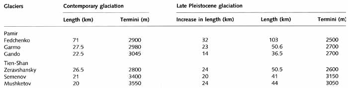
Table 16.5 Parameters of glaciers at present and in the Pleistocene
The depression of the snow line was greater in the peripheral regions, reaching 450 m
in the northern Tien-Shan and 600 m in the Darvaz Ridge, than in the inner mountains
(Troflmov, 1993).
Although there are differences in quantitative evaluation of the extent of glaciers,
most researchers now agree that the Pleistocene glaciation was of the mountain valley
type. Until recently, there was a controversy about this issue. Similarly to Kuhle (1987),
who advocates extensive glaciation in Tibet in contradiction to many other researchers
(e.g., Holmes and Street-Perrott, 1989), Grosswald put forward a hypothesis of ice sheet
glaciation in the Central Asian mountains (Grosswald and Orlyankin, 1979). His model was
built on two premises: a strong depression of the July air temperature for Central Asia
(Gates, 1976) and the adoption of a 900 m depression of the firn line as an average for
the Northern Hemisphere. If this hypothesis were true, after the retreat of the ice sheet
melt-water runoff would have created large zones of alluviation and there is no
geomorphological evidence confirming such episodes (Lebedeva and Khodakov, 1984).
The paleogeographic interpretation of the glacial history of the Central Asian
mountains is debated. Previously, the major school of thought was that during glacial
periods, pluvial conditions prevailed. A stable zone of high pressure was established over
the East European ice sheet and Siberia, with a ridge extending towards Central Asia. In
summer, a thermal low was centred over Central Asia. While high pressure remained centred
over the glaciated East European plain, it was not pronounced over Eastern Siberia in the
absence of an ice sheet. Consequently, depressions of the Atlantic origin migrated
southwards of their modern tracks (over the Black Sea, the Caucasus, the Caspian, and the
Turanian plain), forcing higher precipitation over the Central Asian mountains. Later, the
pluvial concept was advocated by Nikonov et al. (1989) whose reconstructions of the
Quaternary vegetation revealed that when the expansion of glaciers occurred in highlands,
coniferous and deciduous forests developed in the lower mountains, which could only happen
in humid conditions. In contrast during the interglacials, less moisture-demanding
vegetation advanced to higher altitudes giving way to xerophilous associations below.
However, other research has indicated that a reverse situation might indeed have occurred
in the Central Asian mountains and particularly in the Pamir which was affected by the
intense upheaval (Velichko and Lebedeva, 1974). This concept is supported by the
researchers of the loess regions and many palynologists (Serebryanny, 1984; Serebryanny et
al., 1993). Thus Grigina (1981) provided evidence that during the interglacials
broad-leaved forests developed in the northern Tien-Shan, which points to warm and humid
conditions, while spruce forests with the participation of boreal species existed during
both glacials and interglacials. Analysis of sediments from Lake Chatyrkel in the central
Tien-Shan indicated a higher proportion of tree and meadow-species pollen dated to the
warm interval preceding the last Pleistocene glaciation (Shnitnikov, 1980). This testifies
to an upward expansion of the forest belt which is characteristic of warm and humid
conditions. The subsequent cooling of climate, which occurred across the region, was
characterized by the impoverishment of flora. In the Pamir, it was accompanied by the
expansion of the dry steppe vegetation typical of the arid climate similar to that of
today (Pakhomov, 1972).
It should, however, be stressed that migration of the tree line and climate of the
extraglacial regions might be affected by changing glacier runoff, evaporation, and local
wind regime. Migration of the tree line, therefore, may not signify a transition from an
arid to a pluvial epoch on a regional scale but reflect a local rearrangement of the
moisture balance in response to temperature change. Pakhomov (1991) suggests that arid and
humid periods were not synchronous in the lower (forest) and upper (paleoperiglacial)
belts. Cold stages were humid in the lower belt. In the paleoperiglacial belt, glaciers
and snow fields advanced and katabatic cold winds became stronger, resulting in the
development of cryoarid vegetation possibly due to physiological drought. Similar
environments occur at present in the eastern Pamir. During the warmer stages, xerophilous
associations developed in the lower belt. In the upper belt, following the degradation of
glaciers and weakening of the katabatic winds, convection became stronger and
precipitation increased, causing the upward migration of the tree line. Therefore, while
temperature changes were synchronous in the middle and upper mountains, variations in
moisture regime were not. There is no contradiction between the pluvial nature of warmer
periods in the upper mountains and the general tendency towards aridization in Central
Asia suggested by Velichko and his co-workers (see above). Rather strong regional
differences took place against the background of general aridization of climate.
The amelioration of climate at the end of the late Pleistocene caused a general
tendency for glacier retreat, although periodical advances occurred, most notably at the
boundary of the Pleistocene and the Holocene and in the middle Holocene. The Holocene
glacial and climate change in the Central Asian mountains is reviewed by Kotlyakov et al.
(1991) and Serebryanny and Solomina (1996).
In the Tien-Shan, between 9000 and 3000 BP, glaciers occupied approximately the same
area as they do now (Melnikova and Bakov, 1989). Although it is often claimed that the
degradation of glaciation culminated during the Holocene climatic optimum when the thermal
climate reached its maximum, this conclusion is not supported by palynological studies.
There is no evidence showing that vegetation belts migrated upwards during a particular
period in time. Apparently, in contrast to the Caucasus where thermal optimum did have a
pronounced peak, there was no such culmination in Central Asia (Serebryanny, 1988). About
2000-3000 BP, cooling and an increase in humidity occurred, followed by the advance of
glaciers. Palynological analysis has shown that there were three cold intervals between
2500 and 3000; 1300 and 1800; 600 and 100 BP, and a warm interval corresponding to the
medieval climatic optimum (Shnitnikov, 1980; Melnikova and Bakov, 1989; Serebryanny et
al., 1989). The two latter cold intervals were accompanied by transgressions of the
Issyk-Kul while the warm period occurred during the regressive stage (Tsigelnaya, 1995).
Periods of glacier advances during the Little Ice Age have been reconstructed through
lichenometric surveys of moraines. This technique, described by Innes (1985), is generally
not highly accurate and since it has not been widely used in the Tien-Shan, little is
known about lichen growth rates in this region (Savoskul and Solomina, 1996). However,
inaccuracies of the technique are compensated for by a large number of ages and a good
agreement between them. Thus, moraines in the Terskey-Alatau, which mark the maximum
down-valley advance of glaciers, were dated to the following years AD: 1210-15, 1340-90,
1440, 1540-50, 1590, 1650-60, 1680-1710, and 1730-1910 with the exception of the 1800s
(Serebryanny and Solomina, 1996). The most active glacier advance occurred during the
latest interval and it is during this time that glaciers located on the south-facing
slopes, which experienced fewer fluctuations, reached their maximum extent (Kotlyakov et
al., 1991). However, the Little Ice Age was not an episode of continuous cooling but
rather a sequence of cooler and warmer periods with mean summer temperatures varying
within a range of 2.0-2.5°C. The warmer periods lasted 20-30 years and recessions of at
least small glaciers were possible (Serebryanny and Solomina, 1996).
Commenting on the regional aspects of glacial change, Savoskul and Solomina (1996) note
that smaller and more active glaciers of the peripheral regions were more sensitive to
climatic fluctuations than the large and stable glaciers of the inner regions, which is
consistent with the contemporary mass-balance variability. Partly this is because of the
higher inertia of large glaciers, but a difference in climatic conditions in the marginal
and inner regions may also be an important factor. In the inner Tien-Shan, the cooler
stages of the Holocene could have been drier in comparison with the warmer ones, while in
the marginal ridges of the northern and western Tien-Shan the reverse may have been true.
Thus palynological analysis of sediments from Lake Chatyrkel in the central Tien-Shan has
shown that the warm mid-Holocene was relatively humid, while the cold late Holocene was
dry (Shnitnikov, 1980) and similar conditions are believed to be typical of the Tibetan
plateau (Savoskul and Solomina, 1996). In contrast, dendrochronological reconstructions
have shown that in the 18th and first half of the 19th century, the Kungey-Alatau
mountains received nearly twice as much precipitation as at present and between the
mid-17th and the early 19th century the Issyk-Kul overflowed to the river Chu (Kotlyakov
et al., 1991).
In comparison to the Tien-Shan, research in the Pamir and Pamir-Alay has been limited
and correlation between different types of analysis is often poor. Thus, palynological and
radiocarbon data suggest that relatively cold and humid conditions occurred between 7500
and 5000 BP in the middle (1500-3500 m) Darvaz, Gissar, and Peter the First Ridges
(Nikonov et al., 1981). However, later research has suggested that warming occurred in
these regions between 8000 and 4000 BP but did not extend into the inner regions of the
Pamir (Nikonov et al., 1989). According to palynological analysis by Nikonov et al.
(1981), the period between 3500 and 2000 BP was warmer and drier than the middle Holocene
while Serebraynny and Solomina (1996) point at the archaeological evidence testifying to
the occurrence of woody vegetation in the Pamir which could only exist under more humid
conditions. According to Suslikov and Koshkina (1989), this period was marked by a cool
and dry climate as indicated by radiocarbon dating of the relict permafrost to 2900 ± 700
BP. Location of the high floodplains below the older Holocene terraces, dated to 2600 +
800 BP, also confirms that aridity was increasing in comparison with the Holocene climatic
optimum (Susilikov and Koshkina, 1989). On the balance of evidence, Serebryanny and
Solomina (1996) conclude that climate between 2900-2600 and 800 BP was cooler and wetter
than now and glacier advance apparently occurred. However, they emphasize that the
relationship between thermal and moisture regimes in the Pamir-Alay and Pamir in the
Holocene has been complicated and, therefore, the use of climatic data in the
interpretation of the state of glaciation is limited. It should be emphasized that more
often than not, correlation between the climate of low and middle mountains and climate of
high mountains is poor and palynological data or radiocarbon ages for lower altitudes are
not representative of changes in the high mountains and cannot be used as reliable proxies
for glacial changes.
Since the pioneering research of Zabirov (1955), researchers have been in agreement
that following the medieval climatic optimum, glaciers advanced in the Pamir and
Pamir-Alay between the 15th and the 19th centuries. However, reconstruction of the
regional Holocene temperature record has proved difficult. The data on summer temperatures
provided by dendrochro-nologies, obtained in various regions, correlate poorly and only
the main depressions in temperature coincide. Thus, Maksimov and Grebenyuk (1972)
distinguish four cold periods indicated by reduced juniper growth; the 13th century, late
14th-15th centuries, late 17th – early 18th centuries, and the first half of the 19th
century. According to Mukhamedshin (1972), it is the 8th and 9th centuries that were
distinguished by low summer temperatures while summers between the mid-12th and the late
13th centuries and between the 1430s and the mid-16th centuries were warmer. The later
cold intervals correlate well with those obtained by Maksimov and Grebenyuk (1972).
A comprehensive review of climatic and glacial reconstructions for the mountains of
Central Asia and Kazakhstan was recently published by Solomina (1999).
<<< Contemporary Climate | Biomes & Regions Index | Modern Glaciation
>>>
Contents of the Mountains of Central Asia and
Kazakhstan section:
Other sections of Biomes & Regions:
|
|


