Please put an active hyperlink to our site (www.rusnature.info) when you copy the materials from this page
Biomes and Regions of Northern Eurasia
The Caucasus
<<< Introduction | Biomes & Regions Index | Modern Climate
>>>
Physical Geographical Regions of the Caucasus and Transcaucasia
The main physical geographical regions of the Caucasus and Transcaucasia are shown in
Figure 15.1.
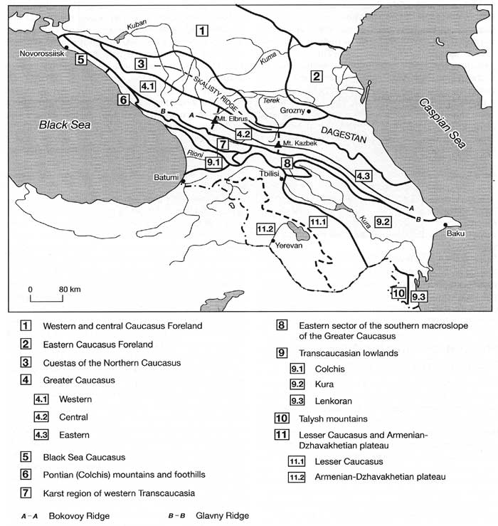
Fig. 15.1 Physical-geographical regions of the Caucasus
These include the cuesta region of the Greater Caucasus, Dagestan, the Greater
Caucasus, the Black Sea, and the Pontian Caucasus, the southern macroslope of the Greater
Caucasus, lowlands separating the Greater and the Lesser Caucasus, the Lesser Caucasus and
the Armenian-Dzhavakhetian plateau.
The cuesta region of the Greater Caucasus consists of three ridges with steep southern
or south-western and gentle north-eastern slopes running parallel to the Glavny Ridge:
Lesisty (absolute heights 800-1000 m), Pastbishny (1200-1500 m), and Skalisty (1500-3600
m). The formation of the cuestas is linked to the differential weathering of sandstones,
limestones, marls, and clays of which the area is composed. The valleys of the Kuban,
Kuma, and Terek rivers divide the cuestas into massifs which also have an asymmetrical
shape: the western slope has a character of gently sloping plateaux while the eastern
slope is very steep. Skalisty Ridge, which received its name (meaning 'rocky') from its
steep southern slope, has local elevations of 300-400 m. Extending across the Caucasus, it
plays an important part in the formation of regional climates. The northern slopes of the
cuestas (especially the Skalisty Ridge which is the highest) receive abundant
precipitation while the valleys, extending between them, and regions, located in the
rainshadow, have much drier environments. Melt water and abundant precipitation on the
northern slopes, combining with limestone and other calcareous rocks, predetermines the
widespread development of karst. Karst landforms include sinking streams, caves, and
depressions developing on the surface. The latter often exceed 100 m in depth and 200 m in
diameter. Karst plays an important role in the formation and supply of aquifers. Surface
water sinks through the limestone until it reaches impermeable clay and marl strata where
below ground reservoirs or streams develop. The water then emerges under substantial
pressure forming numerous springs in the foothills and in the highest eastern sector of
the Skalisty Ridge springs also occur in the mountainous areas (Gigineishvili, 1979). Lake
Cherik-Kel in the Cherek valley, which has a depth of 254 m and is one of the deepest
lakes in Russia, is nourished by such springs (Gigineishvili et al., 1983).
Located in the eastern Caucasus, Dagestan can be subdivided into the north-western
mountainous region, inner Dagestan, and the eastern foothills. North-western Dagestan
includes the eastern part of the Skalisty Ridge with altitudes exceeding 3000 m, and lower
chains extending along the Skalisty. The mountains intercept moisture from the Caspian and
the Eastern European plain and their northern and north-eastern slopes receive 800-900 mm
of precipitation per annum while the adjacent plains receive 400-500 mm. Similarly, the
eastern foothills and slopes receive more moisture from the Caspian than the coastal
regions occupied by semi-deserts. The original mountainous vegetation in north-western and
eastern Dagestan is deciduous forests and meadows but it has been bly altered by human
activities. As in the cuesta region, karst is well developed and there are numerous
springs and lakes of karst origin. Inner Dagestan is a mountainous region with plateaux
and ridges reaching an altitude of 2000-2700 m and valleys positioned at 600-700 m.
Surrounded by high mountains on all sides, it has a distinctly arid climate. At an
altitude of 1000 m, annual precipitation is about 500 mm, while evaporation is twice as
high (Gigineishvili, 1979). Geomorphology and exogenic processes are different from those
in the other parts of Dagestan (e.g., the development of karst is very limited) and
vegetation is dominated by xerophilous communities.
The Greater Caucasus is subdivided into western, central, and eastern sectors with the
borders corresponding to the highest summits, the Elbrus and the Kazbek. In the west, it
is flanked by the Black Sea Caucasus whose altitudes increase from 500-1000 m in the west
to 3000 m in the east. On the eastern flank, altitudes decline eastwards towards the
Caspian from about 3000 m to 500 m. The main ridges of the Greater Caucasus are the Glavny
(also known as Vodorazdelny) and the Bokovoy Ridges where the tallest summits, six of
which exceed 5000 m, are located. The Greater Caucasus forms the major climatic and
environmental divide. High altitudes and abundant precipitation provide for the
development of modern glaciation which is discussed on below. Tectonic uplift, recent
volcanic activity, Quaternary and modern glaciations and active exogenic processes have
given the Greater Caucasus its characteristic alpine landscape (Plate 15.1).
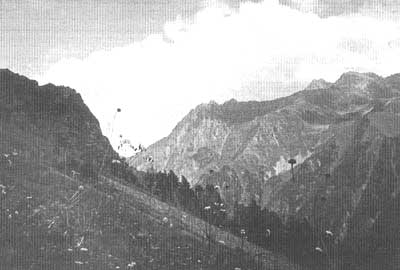
Plate 15.1 The Greater Caucasus: near the timber line (photo: courtesy
of Dr T. Galkina, The Institute of Geography, Russian Academy of Science, Moscow)
It is bly dissected with a multiplicity of erosional and glacial landforms. Altitudinal
zonality in the distribution of vegetation is well developed and discussed on below. In
brief, in the western sector of the Greater Caucasus, which has large absolute heights and
a mild and humid climate, mountainous forests, and meadows are widespread. The mountains
are mainly composed of crystalline rocks and the rates of weathering and erosion are
comparatively low. In the central sector, which has the highest elevations and,
consequently a cool and humid climate, meadow ecosystems are most widespread (these become
more xerophilous in the landlocked Elbrus region) as well as nival environments. It is the
most widely glaciated area in the Caucasus and glacial landforms determine the landscape
of the high mountains. In the eastern sector, lower altitudes predetermine a lesser extent
of modern glaciation and as aridity increases, xerophilous environments become more
widespread. The region is composed mainly of shales that weather relatively easily. The
weathering and erosion rates are very high and ancient glacial forms have largely been
eroded.
The Black Sea Caucasus extends along the Black Sea coast as a system of ridges with
altitudes of 500-700 m whose height increases eastwards to the maximum altitude of 2900 m.
These are composed mainly of marl flysch and limestone but because of low humidity,
weathering rates are low. Climatic conditions and river regimes resemble those of the
Mediterranean and xerophilous vegetation dominates the area. The Pontian or Colchis
mountainous region extends further east of the Black Sea Caucasus. The division is based
on climatic differences: the Pontian Caucasus receives much more precipitation and has a
very humid climate. Under the conditions of high humidity, flysch, marls, and clays, which
compose much of the region, are easily eroded and hills have relatively low altitudes and
gentle, rolling forms. These alternate with mountainous chains with the southeastern
strike. The mountains, built of limestone, are cut by narrow river valleys and karst is
widespread.
The Gagra and Bzyby Ridges, the southern spurs of the Kondor, Svanety, and Megrel
Ridges, the Rachinsky Ridge and the Askhi plateau form the so-called karst region of
western Transcaucasia. The large spatial and vertical extent of limestone (limestone
strata exceed 2200 m in thickness) and abundant precipitation (in the western part of the
region, slopes receive 1500-2500 mm a-1 at an altitude of 1500 m) predetermine
the ubiquitous development of karst at all altitudes. The full range of karst landforms
occurs in the region. At lower altitudes, caves reaching 5 km in length, shafts exceeding
200 m in depth, and sinking streams are typical, while karren landscapes develop in the
mountains. High mountains are virtually devoid of surface runoff as water sinks through
the limestone while in the lower mountains, karst springs with high (up to 10 m3s-1)
water discharges develop (Gigineishvili, 1979). Karst landforms are often superimposed on
the glacial landforms created by the Pleistocene ice. Relict karst is widespread too. Deep
karst cavities developed in the Jurassic limestones are overlain by the Eocene clays,
testifying to the long history of karst formation in the region which dates back to the
Jurassic (Gvozdetsky, 1992). The large amount of calcium in the soil predetermines the
development of specific habitats which are drier than can be expected in this climate and
accommodate various calcicole species that are not found elsewhere. Thus, in the subalpine
and alpine meadow altitudinal belts, 33 per cent of species are endemic (Gvozdetsky,
1954). Soil cover is thin, the profiles are poorly developed and contain large amount of
rock debris. As a result, vegetation cover is often sparse. It is easily destroyed by
extensive grazing and widespread erosion follows.
The southern macroslope of the eastern Greater Caucasus comprises highlands and ridges
of predominantly medium (about 2000 m) height: the highlands of Imeretia, the Surami
Ridge, and the mountains of Southern Ossetia, Karthalinia, and Kakhetia. The ridges, which
have a meridional strike, lead away from the Glavny Ridge with the altitudes declining
southwards. Protected by the Greater Caucasus from the north, this region has a mild
climate which becomes progressively more arid eastwards as annual precipitation totals
decline from 1500 mm in the west to 600 mm in the east.
There are three main lowlands in the Caucasus: the Colchis, Kura, and Lenkoran. The
Colchis lowland (also known as Kolkhida or Rioni) and the Kura lowland, divided by the
transverse Surami Ridge, comprise the Rioni-Kura tectonic depression. The Colchis lowland
is a young accumulative plain formed during the Pliocene-Quaternary when the whole region
experienced uplift. The Miocene marine basin, which existed in its place, was filled by
sediments whose thickness reaches 700 m. At present, the Colchis lowland subsides at a
rate of 0.6 cm a-1 (Gornye strany, 1974). However, a number of rivers,
beginning in the Glavny Ridge and the mountains of Adzharia and Imeretia, drain the
Colchis lowland delivering and depositing a vast amount of alluvium at a rate exceeding
100 million m3a-1 to the coast and beyond. The Rioni is the largest
river with a length of over 300 km and a vast, 20-30 km wide, delta. The sediment
discharge by the Rioni is particularly high and intense accumulation occurs in its
estuary, filling the delta and extending the coastline (Tushinsky and Davydova, 1976).
Coastal dynamics are extremely complex in the Colchis lowland and while in some areas the
net result is the expansion of land, in other regions the coastline retreats despite the
high sediment delivery. One of the reasons for the retreat is the occurrence of numerous
submarine canyons in which alluvium is deposited (Zenkevich, 1990). The Colchis lowland
has a flat topography with altitudes gently increasing landwards. It comprises relict
river deltas and river-mouth bars and ramps, and relict alluvial deposits. Originally,
much of the lowland was swampy and, although extensive improvements have been made, swamps
still occupy large areas. The warm and moist climate of the Colchis lowland preconditions
the development of lush vegetation containing many relict species. Having survived from
the Tertiary, the vegetation in the foothills is especially rich floristically while on
the lowland itself, plant communities are less diverse because of the lowland's young age.
Little of the climax vegetation survived on the Colchis lowland with the exception of
riparian forests because it is a major agricultural region growing tea, grapes, and citrus
fruits. These and many other species were introduced in the 19th century and at present
agricultural ecosystems dominate. Of introduced plants, eucalyptus, used in amelioration
projects, is particularly widespread.
The Kura (or Kura-Araks) lowland extends between the Surami Ridge and the Caspian Sea.
Absolute altitudes decline from the west (450 m above sea level) to the east where the
delta of the Kura is located 25 m below mean sea level. The lowland is composed of marine
sediments in the east, deposited during the Quaternary transgressions of the Caspian, and
alluvium delivered by the Kura and the Araks. Protected by the Greater Caucasus from the
north and the Surami and Likhvin Ridges from the west, the Kura lowland has a dry climate
with 200-400 mm precipitation per annum. Semi-deserts and sparse arid woodlands represent
the zonal vegetation. The ground water table is close to the surface and topographic
depressions are often swampy. Wetland vegetation communities, developing in such habitats,
are represented largely by Phragmites communis and Bolboschoenus maritimus while riparian
forests develop along the Kura and the Araks.
The Lenkoran lowland is located south of the Kura lowland, extending between the
eastern foothills of the Talysh and the Caspian. It has a very warm and moist climate with
annual precipitation totals exceeding 1200 mm. Climax vegetation communities comprise many
Tertiary species but natural forests have been largely destroyed and replaced by
agricultural ecosystems. Natural ecosystems are preserved in coastal wetlands, which are
widespread in Lenkoran, and in nature reserves.
The mountainous regions of the Lesser Caucasus and the Armenian-Dzhavakhetian plateau
are located south of the Rioni-Kura depression. The Lesser Caucasus consists of a system
of mountainous ridges with altitudes of 2000-2800 m in the west and 2500-3300 m in the
east. The Armenian-Dzhavakhetian plateau comprises volcanic plateau composed of tuffs,
basaltic and andesitic lavas with absolute heights of 600-1500 m, mountainous massifs
rising to 2500-3000 m, and volcanic cones exceeding 4000 m. The two highest summits,
Ararat (5165 m) and Aragats (4095 m) are volcanic cones carrying ice caps. Both are
considered inactive although minor eruptions of the Aragats occurred in early historical
times (Nalivkin, 1973). The potassium-argon dates, obtained by Mitchell and Westaway
(1999), suggest that Quaternary volcanism began in the Lesser Caucasus and the
Armenian-Dzhavakhetian plateau before 1.1 Ma BP, and reached its peak around 0.8 Ma BP.
The climate of the region is arid with a high degree of continentality. The lack of
precipitation and the high permeability of volcanic rocks lead to meagre surface runoff
and the development of xerophilous vegetation communities, many of which have been altered
over the centuries of human activity.
<<< Introduction | Biomes & Regions Index | Modern Climate
>>>
Contents of the Caucasus section:
Other sections of Biomes & Regions:
|
|


