Please put an active hyperlink to our site (www.rusnature.info) when you copy the materials from this page
Biomes and Regions of Northern Eurasia
The Mountains of Southern Siberia
<<< Mountains of the Baikal Region and
Transbaikalia | Biomes & Regions Index | The Caucasus: Introduction >>>
The Stanovoy and the Dzhugdzhur Ridges
Although on the map the Stanovoy and the Dzhugdzhur Ridges appear as a continuation of
each other, they belong to two different fold belts (the Urals-Okhotsk and the Pacific
respectively) and are independent orographic entities. The formation of the Stanovoy Ridge
was discussed above. The Dzhugdzhur belongs to the Pacific fold belt. Typical of this belt
are the alternation of uplands and plateaux, with lowlands widening towards the Pacific
coast; the orientation of mountainous chains and depressions along the continental
flexures; the different ages of depressions (lower and middle Paleogene in the north and
Neogene further south); intense volcanism in the late Mesozoic and early Cenozoic; a
decline of the volcanic activity from north to south during the Mesozoic-Cenozoic; and
high seismicity at present. The tectonics of the Pacific belt are discussed in more detail
in other sections.
The Dzhugdzhur: Morphology, Environmental History, and Exogenetic Processes
The first research expeditions visited the Dzhugdzhur in the middle of the 19th century
and described the mountains as 'enormous heaps of gravel with sliding tops' (active scree
slopes) (Shegolev, 1906). In modern geography, the Dzhugdzhur Ridge is classified as
highlands formed by a combination of orographic and geomor-phological units: meridional
ridges, intermontane depressions, isolated mountainous massifs, and sections of coastal
plains (Chemekov, 1975; Bredikhin, 1987). It consists of two major orographic regions: the
first one is formed by block mountains separated by depressions and another is constituted
by uplifted domes.
The block ridges and depressions run parallel to the Sea of Okhotsk coast. The
easternmost part is occupied by the Pribrezhny Ridge (meaning 'coastal') extending from
north to south for over 300 km. The ridge has an average elevation of 600-800 m and
isolated peaks of about 1200-1300 m. The eastern slope drops sharply towards the Sea of
Okhotsk coast, forming cliffs higher than 300 m. Tectonically, this is a fault separating
the coastal plain and the shelf from the mountains of the Pacific fold belt. The adjacent
narrow Lantar-Nemuisk valley, dividing the Pribrezhny and the Vodorazdelny Ridges, is a
clearly defined graben which did not experience any significant subsidence in the
Cenozoic. The Vodorazdelny Ridge is the highest in the Dzhugdzhur (hence its name,
'watershed') and has elevations of 1300-1600 m. Typically of the Dzhugdzhur, its shape is
asymmetrical: the weakly dissected and steep eastern macroslope descends in a sequence of
steps towards the Lantar-Nemuisk valley at an angle of 20-25°, while the western
macroslope gently merges into the Uchur-Maisk plateau. Proterozoic gneisses and schists
with intrusions of anorthosites occur in the axial section of the Vodorazdelny Ridge. The
Lantar-Nemuisk valley and the Pribrezhny Ridge are composed of relatively young Mesozoic
volcanic rocks, secured to the basement by Cretaceous granitoid intrusions which are
clearly associated with topographic swells. The boundary between the areas composed of the
Proterosoic and Mesozoic rocks passes along the western part of the Lantar-Nemuisk valley
and shows in relief as a chain of deep saddles and hills.
The north-east is dominated by a chaotic arrangement of uplifted domes separated by
valleys. Coincident with the domes are the highest elevations in the Dzhugdzhur including
the absolute maximum height of 1906 m. This section is built primarily of Mesozoic
terrigenous-volcanic rocks, ruptured by siliceous intrusions which are responsible for the
anomalies in hypsometry. As elsewhere in the Dzhugdzhur, the eastern macroslope is steep
(15-20°) and short (about 30 km) while the western macroslope runs for 50-60 km and at an
angle of no more than 10° towards the Aldan tableland.
The topography of the Dzhugdzhur results from neo-tectonic reactivation of Paleogene
relief (Figure 14.11). The uplifted peneplanated surfaces (which in contrast to the Altay
and Sayan mountains have dimensions of just a few kilometres) occur at an altitude of
900-1500 m and the subsided sections can be traced at the bottoms of depressions and on
the shelf. During the Quaternary, the uplift was accompanied by repeated glaciations
(Chemekov, 1975; Khudyakov, 1977; Likutov, 1983). While the glacial history of the Altay
and the Sayans has been extensively studied, research on environmental change in the
Dzhugdzhur has been limited. The currently available evidence testifies to the occurrence
of a cold and a warm epoch in the middle Pleistocene and two cold and two warm epochs in
the late Pleistocene, but there is still no agreement on the rank of these events
(Korotky, 1993).
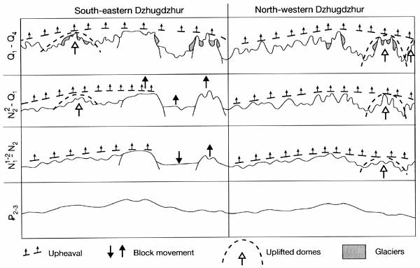
Fig. 14.11 Development of the relief in the Dzhugdzhur in the Cenozoic
During the middle Plesitocene glaciation, the ice spread from the Aldan tableland.
Erratic material occurs widely on the western macroslope and on the watersheds, pointing
to the reticulated nature of glaciation (Likutov, 1983). Traces of the middle Pleistocene
glaciation are less widespread on the eastern macroslope and are absent in the Pribrezhny
Ridge, possibly because of the greater glacial activity in the late Pleistocene. In the
late Pleistocene, the development of glaciers in the Dzhugdzhur (as across the rest of the
Pacific glacial province to which it belongs) was controlled by the monsoon and glaciation
was more extensive in the coastal ridges and east-facing slopes opened to the
moisture-bearing flow. Closer to the coast, glaciation was of a reticulated type and the
ice probably descended onto the Sea of Okhotsk shelf (Bredikhin, 1995). Landwards, the
lateral extent of the ice diminished and the snow line became progressively higher, rising
from 800 m in the south-east to 1000 m in the north-west during the first late Pleistocene
glacial. During the latest glacial, the ice spread across the highest ridges and massifs
of the Dzhugdzhur, attaining its maximum extent on the eastern slopes of the Vodorazdelny
and Pribrezhny Ridges. The position of the snow line has been reconstructed at
approximately 900-1300 m. There are numerous cirques and glacial troughs in the high
mountains. The position of terminal moraines bounding short glacial troughs confirms that
most glaciers had a length of 4-6 km, with only few reaching 10 km. On the lower slopes
and in the Lantar-Nemuisk valley accumulative landforms were largely destroyed by late
Pleistocene melt water, transported from the higher mountains in short (25-40 km)
channels. At present, the inter-montain depressions and large river valleys are occupied
by fragments of the outwash plains in the form of terraces composed of alternating layers
of till and fluvioglacial deposits.
The drainage network of the Dzhugdzhur developed in the Miocene-early Pleistocene when
river valleys formed during the uplift. They were later modified by tectonic and glacial
activities. The earliest alluvium uncovered in the buried valleys on the eastern
macro-slope is dated to the Pliocene but most alluvial sediments are of Pleistocene age.
These are formed of coarse boulders and gravel intermingled with layers of sand and are
derived from glacial and fluvioglacial deposits.
On the eastern and western macroslopes, river valleys have different structures
(Bredikhin, 1987). On the steep eastern macroslope, rivers are short (mostly under 50-80
km) with steep gradients and their channels are shallow and with numerous cornices.
Terraces of Neogene-early Pleistocene age have been largely destroyed by tectonic uplift
and younger fluvioglacial forms of middle and early Pleistocene age dominate downstream.
In their upper courses, rivers have V- or U-shaped valleys which are between 200 m and 500
m wide. River terraces are low and often fragmentary. In the middle and lower courses,
river valleys widen to 1.5-2 km and acquire a trapezium-like shape. River terraces occur
at an altitude of 100-120 m. Rivers of the western macroslope begin on the flat watersheds
of the main ridges and their valleys retain the V-shaped plan along the whole course.
Valleys are broad (5-6 km) and slopes have small gradients. Terraces are low, rarely
attaining an elevation of about 40 m. The continuing uplift of the ridge intensifies river
incision, particularly on the steeper eastern macroslope which also receives more
precipitation. As a result, capture of the westerly part of the drainage system by the
easterly rivers is a common phenomenon in the Dzhugdzhur. Saddles with a depth of 100-150
m develop in the upper courses of many rivers, erasing the boundaries between the adjacent
basins and creating almost continuous valleys cutting through ridges.
Slope processes in the Dzhugdzhur are those typical of periglacial environments.
Intense frost weathering leads to the widespread formation of block fields and streams.
The occurrence of permafrost predetermines the development of solifluction especially on
the southern and south-eastern slopes where freeze-thaw cycles are more frequent and where
higher precipitation ensures saturation of soils. In winter, avalanches are common.
The Stanovoy Ridge: Morphology and Environmental History
The Stanovoy Ridge extends from south-west to northeast for more than 900 km from the
Olekma valley in the west to the Uchur valley in the east. Its eastern section, known as
the Tokynsky Stanovik, is the highest, with a maximum elevation of 2412 m and peaks
exceeding 2000 m. In its different sections, the ridge consists either of three to four
parallel ridges or one major chain and branching side ridges (e.g., the Atgsky, Maisky,
and others). Valleys largely coincide with faults which have either a latitudinal or
sub-meridional strike. Strong dissection, especially in the Tokynsky Stanovik, and
numerous fault dislocations transformed slopes, particularly in the south, into a series
of sharply denned steps giving the ridge a craggy alpine landscape and making it virtually
inaccessible. However, in many areas the uplifted peneplanated surfaces have survived and
their remnants are particularly common between 800 and 1000 m. The Neogene-Quaternary
orogeny was accompanied by emissions of basalts to which plateaux in the basins of the
Aldan and Zeya owe their origin. .
Although it is known that the Stanovoy Ridge was repeatedly glaciated in the
Quaternary, paleoenviron-mental reconstructions for this region are extremely few and
refer mainly to the eastern part of the ridge. Thus geomorphological evidence for
glaciation during the maximum cooling of the late Pleistocene is described by Chemekov
(1975) for the eastern Stanovoy Ridge. According to this research, glaciation was
predominantly of the mountain valley nature as evidenced by numerous cirques, glacier
troughs, and edge moraines with the exception of the Tokinsky Stanovik where piedmont
glaciers developed.
The Stanovoy Ridge separates the Pacific and the Arctic basins. The drainage system,
which is a combination of lengthwise and lateral valleys, has maintained its general
direction through the uplift of the ridge. The largest rivers begin in the southern ridges
and flow northwards, cutting through the mountains where they form deep valleys and
widening in the intermontane depressions. Examples of river capture are numerous and
usually it is rivers of the south-eastern macroslope facing the Sea of Okhotsk that
capture the rivers of the north-eastern slope which have a higher base level.
Climate, Soils, and Biota
Both the Dzhugdzhur and the Stanovoy mountains have severe climates. In coastal
regions, the atmospheric circulation has a monsoonal nature and the summer monsoon reaches
into the landlocked sections of the Stanovoy Ridge, providing for the late summer maximum
in precipitation. On the coast, the annual amount reaches 900 mm and about 90 per cent of
it occurs in the late summer. Summers are cloudy, foggy, and cold on the coast. The mean
July temperatures are about 12°C increasing to about 19°C on the western side of the
Dzhugdzhur. In winter, the opposite spatial temperature pattern develops: mean January
temperatures range between -20°Ń and -25°C on the coast dropping to -42°C across the
mountains. The growing season is therefore short.
Soils of both ridges belong to the East Siberian province (Glazovskaya, 1981). The
Dzhugdzur is located in its northern, the so-called sparse forest, subzone while the
Stanovoy is situated in the taiga biome. Soils change with latitude and altitude from
podzols in the south to gley soils in the areas of permafrost distribution in the north
and in the high mountains. In both regions, the formation of soils proceeds at a very slow
rate because of the short summer, permafrost, and deep seasonal freezing, and parent
material resistant to weathering. As a result, soil cover is thin, profiles are poorly
differentiated, and contain large amounts of gravel.
Cold summers and strong winds severely hamper the development of vegetation,
particularly on the coast. Although the mountains are relatively low, in the coastal
regions their upper parts are free of vegetation. The tree line is positioned lower than
in the inner regions. Vegetation of the Stanovoy Ridge is of the East Siberian type
distinguished by the domination of Larix gmelmii in the forest belt. The Dzhugdzhur
belongs to the Okhotsk geobotanical district where Picea ajanensis, Larix gmelmii, Betula
lanata, and Pinus pumila play prominent roles (Ogureeva, 1999a, b). Picea ajanensis is a
predominantly mountainous species which occurs across the northern Pacific from Kamchatka
to Japan and penetrates into the East Siberian taiga along the mountainous ridges which
receive enough precipitation to support this species. In favourable conditions Picea
ajanensis can attain a height of 30-50 m but having a shallow root system it is often
damaged by wind. It prefers loams and a moderate moisture regime, grows on slopes with
thin stony soils but avoids sandy and peaty soils and does not attain the tree line. Abies
nephrolepis is a typical admixture to Picea ajanensis but it is never a major
forest-forming species and is confined to more southern locations. There are several types
of Picea-Abies forest: those developing in the well-drained valley sites have a rich
undergrowth composed mainly of deciduous species; forests growing on steep, well drained
slopes have poor undergrowth but green mosses are abundant. The latter are the most common
and the most productive type which is exploited commercially. Betula lanata can endure the
most unfavourable climatic and soil conditions and often grows on stony substrata. Larix
gmelinii is another species which colonizes areas with a shallow active layer, swamped
sites, and forms secondary successions after forest fires. Pinus pumila, one of the most
hardy woody species, is usually a creeping plant (40-50 cm high) although in protected
sites it may form dense, tall thickets reaching 2-2.5 m in height. Altitudinal gradients
exist in the structure of vegetation both in the Stanovoy and the Dzhugdzhur, although
further north they are less clearly expressed because of the severe climate. Compared to
other mountainous regions, the vertical sequences are simple (Figure 14.12) but their
distribution is not particularly towards the Pacific.
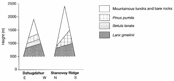
Fig. 14.12 Vertical vegetation sequences in the Dzhugdzhur and the
Stanovoy Ridges
This is because the area is located at the junction of different botanical provinces
and topographic and, consequently, climatic and soil conditions vary substantially. In
comparison with other mountainous regions of Southern Siberia, vegetation as well as many
other aspects of the physical geography of the Stanovoy and the Dzhugdzhur mountains have
not been extensively researched.
<<< Mountains of the Baikal Region and
Transbaikalia | Biomes & Regions Index | The Caucasus: Introduction >>>
Contents of the Mountains of Southern Russia
section:
Other sections of Biomes & Regions:
|
|


