Please put an active hyperlink to our site (www.rusnature.info) when you copy the materials from this page
Physical Geography of Northern Eurasia
Permafrost
<<< Ground Ice | Physical Geography Index | Climate and
Permafrost >>>
Cryogenic Processes and Relief
Cryogenic (periglacial) processes are a collective term used to describe a number of
distinct processes which result mainly from alternate freezing, cooling, and thawing in
soils, rocks, and other materials (Kudryavtsev et al., 1978a; Permafrost Science, 1981;
French, 1996). These processes form cryogenic relief within the periglacial domain and
include frost heaving and ice segregation, freezing of injected water, development of
thermal contraction cracks, and formation of ice (or soil) wedges, thawing of permafrost
(thermokarst), solifluction and frost and cryogenic weathering of soil, ground, and
bedrock. These processes occur across the cryolithozone. However, there are certain
spatial regularities in their distribution.
Frost Cracking and Polygonal Wedge Relief
Frost or thermal contraction cracking creates the most typical cryogenic landforms: ice
wedge polygon relief, also known as tundra polygons or fissure polygons. Sand or soil
wedges are another type of frost fissure which develop when cracks are filled with mineral
soil or sand (Pewe, 1959; Kudryavtsev et al., 1978a; French, 1996). However, sand- or
soil-wedge polygonal relief is not characteristic of Russia. According to Popov (19626)
and Dostovalov and Popov (1966), the size of the polygonal net reflects severity of winter
climate, since low winter temperatures encourage thermal cracking. This process is also
regulated by snow depth due to the insulating effect of snow cover. The Taymyr peninsula
and Eastern Siberia are the major regions of ice-wedge polygon occurrence. Various
landscapes (plains, lowlands, wetlands, river floodplains, river and marine terraces,
watersheds, gently inclined slopes) are characterized by different patterns of polygonal
relief. In Western Siberia and in north-eastern European Russia ice-wedge polygonal relief
is observed only in the continuous permafrost zone within wetlands in river valleys,
watersheds, and peatlands (so-called flat-topped polygonal peatlands). In Eastern Siberia,
it extends up to the massive-island permafrost zone where it occurs in river valleys and
wetlands. Size, form, and age of polygons vary in response to such factors as air and soil
winter temperature, soil composition, ice content, specifics of sedimentation, ground
drainage, and vegetation (Dostovalov and Popov, 1966; Popov, 1967; Kudryavtsev et al.,
1978a; French, 1996). Typical dimensions of ice-wedge polygons range between 5-20 m in
peaty soils and 10-50 m in mineral soils. On low marine terraces, composed of saline
deposits, polygon dimensions can reach 100 m (Geocryology of the USSR: Eastern Siberia and
the Far East, 1989).
The main stages of ice-wedge polygonal relief evolution are growth, conservation, and
degradation. The ground polygonal nets have different patterns, including orthogonal
random, oriented, and hexagonal (French, 1996). Typical of growing ice-wedge polygonal
systems (rampart polygons) is a raised rampart on either side of the fissure with a height
of 0.3-0.8 m. Typical young growing polygons with ramparts are characteristic of the river
floodplains in the Taymyr peninsula. The destruction of polygonal thick ice wedges by
melting and thermoerosion leads to the formation of alases (thermokarst lowlands and
lakes) and baydjarakhs (thermokarst mounds also known as graveyard mounds), which occur in
northern and central Sakha-Yakutia. In the stage of degradation, polygons develop
convexities with deep thawing furrows (dome-like mounds in appearance). Domed polygons
with soil wedges inside the furrows is typical of Bolshezemelskaya Tundra (Konishchev and
Tumel, 1989). Several cryogenic processes control their formation: thermal contraction,
which forms polygons with ice wedges; thawing and thermokarst; solifluction and nivation,
which transforms polygons into mounds and ice wedges to soil wedges. The relief-forming
processes are accompanied by cryogenic weathering which transforms coarse and fine-grained
deposits into cryogenic clay eluvium ('cover' clay), a phenomenon known as 'polar cover
complex' (Popov, 1962a).
Frost Heave and Frost Mounds
Frost heave results from water migration to the level of freezing and its subsequent
segregation into ice layers and lenses (Popov, 1967; Kudryavtsev et al., 1978a; French,
1996). This occurs wherever moisture is present and sediments or soils are
frost-susceptible. Localized and intense frost heave forms small (0.5 m-1.5 m) seasonal
mounds and large (3-8 m) perennial mounds. The more widespread and typical annual ground
displacements are of 5-20 cm. These hamper construction and maintenance of roads,
buildings, and pipelines in permafrost environments. Other forms of frost mounds, for
example, bulgannyakhs (pingos) and hydrolaccoliths, are described above. Note, that
bulgannyakhs, which form on lake bottoms, are exposed to the new perennial freezing in
alases, drained lakes, and in the deltas of large rivers of Eastern Siberia. These mound
shapes are attributed to cryostatic (i.e., freezeback) pressures generated in taliks under
lake bottoms and this is why they are typical of northern and central Sakha-Yakutia, where
lakes occupy above 50 per cent of the entire area.
Thermokarst
Thermokarst (a term first introduced by M. Ermolaev in 1932) is a process of ground ice
melting accompanied by subsidence of the ground surface (Brown and Kupsch, 1974;
Kudryavtsev et al., 1978a; French, 1996). Thermokarst is among the most important
processes shaping permafrost landscapes. It develops in response to the disruption of the
thermal equilibrium of permafrost and is controlled by such changes in the environment as
climatic warming, increase in snow cover, and an increase in seasonal variation of
temperature, deforestation or destruction of vegetation (e.g., due to forest fires),
presence of standing water, and anthropogenic impacts (Popov, 1967; French, 1996).
Thermokarst is typical of most permafrost regions in Russia, being particularly active on
plains and in river valleys. The most clearly defined forms of thermokarst develop in
areas of high ground ice content, especially where ice-wedge polygons are well developed.
The occurrence of thermokarst on a large scale reflects a long-term climatic
amelioration dating back to the Holocene climatic optimum (Kachurin, 1962; French, 1996).
Contemporary thermokarst is linked with geographical zonation and ice content of
permafrost (Kachurin, 1962). This relationship is not straightforward: as air and ground
temperatures decrease northwards, the occurrence of thermokarst diminishes; however, the
increase in ice content enhances potential for thermokarst development. Thus, the main
controls over thermokarst development in the southern taiga and forest-steppes of Eastern
Siberia and the Far East are relatively warm and long (4-5 months) summers, the depth of
active layer (2-4 m), and the high annual ground temperature (between 0°C and -1°C).
Thawing of frozen ground, whose ice content is low, produces small and shallow thermokarst
forms (although relict thermokarst here has larger dimensions). The causes which can block
the development of contemporary thermokarst include low annual ground temperatures (below
-1°C) and thick vegetation cover, which shields the underlying permafrost from solar
heat. Contemporary thermokarst occurs in the arctic tundra in northern Western Siberia,
Sakha-Yakutia, and the Taymyr peninsula where it is related to the abundance of lakes.
However, due to the extremely low air and ground temperatures and low precipitation which
prevent thawing, present-day thermokarst is relatively rare and relict forms prevail.
Thermokarst is more widespread in central Sakha-Yakutia where the unique environment
strongly favours its development. Here, thermokarst is represented by alases and
baydjarakhs, which form different stages of polygonal relief degradation and constitute
the most outstanding phenomenon of permafrost in Russia. In central Sakha-Yakutia, deep
thawing of frozen ground, which has a high ice content, is caused by the very warm
summers: mean summer air temperatures are around 18°C and maximum temperature in July
reaches 38°C (Regional Cryolithology, 1989). The segregated ice layers in frozen deposits
often account for 50-80 per cent of the total volume of deposits and thick (20-60 m) ice
wedges may occupy between 30 per cent and 60 per cent of the surface (Czudek and Demek,
1970; Soloviev, 1973). The first stage of thermokarst development is thawing of ice
wedges, which creates deep thaw depressions. As soon as these depressions reach 1-1.5 m in
depth, vegetation cover is destroyed, slumping begins, and the polygon cores form
baydjarakhs. These are silty or peaty conical mounds between 3 m and 8 m high, which
inherit the dimensions of the polygons from which they have developed. Young baydjarakhs
have the form of flat topped cones, whereas the tops of old baydjarakhs are more convex.
Through the continued degradation of baydjarakhs, alases develop. An alas has a circular
or oval shape with steep sides and a flat floor often containing a thermokarst lake. Its
area often reaches 25 km2. Taliks form under the young alases. With time, alas
lakes either get filled with deposits or drain to a lower alas or a stream. The talik
freezes and ice wedges and bulgannyakhs begin to develop. The lowlands of Siberia have
been altered considerably by alases and thermokarst lakes. In north-eastern Siberia 60-80
per cent and in central Sakha-Yakutia 40-50 per cent of the initial land surface has been
destroyed by alases (Czudek and Demek, 1970; Regional Cryolithology, 1989). Thermokarst
lakes occupy up to 70 per cent of the terrain in Western Siberia (Regional Cryolithology,
1989).
Thermal Abrasion and Erosion
These processes combine both the thermal and fluvial erosive capacities of running
water and waves (Are, 1980; French, 1996) and result in lateral permafrost degradation due
to cliff and bluff retreat, lateral river thermal erosion, and marine or lacustrine
thermal abrasion. Ground ice slumps and thermo-erosional niches are some of the most
distinctive features developing this way. Niches, which are between 2 m and 20 m deep,
form in the ice-rich silt and clay at the flood-water level along river banks and coastal
bluffs following high tides and storms, because the water temperature is higher than the
temperature of frozen soils. These processes are particularly typical of the Arctic
islands and coastal plains of the Laptev and East Siberian Seas. The formation of niches
can lead to the collapse of the overlying frozen sediments along the boundaries of ice
wedges or massive ice which run parallel to the shoreline. Thus, in 1961 the coastline
retreated by 15 m within two days in Moastakch island in the Laptev Sea (Are, 1980).
Thermal erosion destroyed Vasilyevky and Semenovsky islands in the Laptev Sea (Czudek and
Demek, 1970) with the rate of coastal retreat at Semenovsky island being as high as 55 m
a-1 (Are, 1980). Along the Barents Sea coast, the average retreat rates are between 0.5 m
a-1 and 2.5 m a-1; the maximum rates reach 12 m a-1. The retreat
rates of the Laptev Sea coast are higher and range between 2 m a-1 and 4 m a-1,
with a maximum rate of 55 m a-1 (Are, 1980).
Solifluction
Solifluction is regarded as one of the most widespread processes of soil movement in
periglacial areas. Thawing of the active layer leads to the formation of water-saturated
soils and the presence of permafrost creates an impermeable layer that helps to maintain
water saturation near the surface. Although Solifluction deposits are found practically on
any slope, the occurrence of Solifluction relief is more limited. The following conditions
favour the development of Solifluction: a slope angle of 8-12°, (although it is often
observed within a much wider range of 2-25°); the presence of fine-grained soils,
deposits, and ground, transformed by cryogenic weathering; and availability of
water-saturated thawing soils (Kudryavtsev et al., 1978a). The major influence upon
solifluction is vegetation. Vegetation stabilizes slopes, improves soil structure, and
intercepts precipitation, and for these reasons solifluction is most widespread where
vegetation is sparse (i.e., in tundra). The debris-mantled hillslopes of solifluction
origin are ubiquitous on the western plains of the permafrost zone. Here, solifluction
relief is presented by stripes, tongues, terraces, and garlands. Solifluction in mountains
is characteristic of the lowest belt of the Arctic and subarctic mountains. The typical
solifluction regions are the Chukchi and Taymyr peninsulas where alternating stripes of
fine-grained and coarse stony deposits (sorted solifluction) are found (Regional
Cryolithology, 1989). Another type is the block field or block streams (also termed
kurum), formed by frost weathering of exposed rocks. These are typical of the nival and
tundra mountainous belts of Transbaikalia and the Central Siberian plateau (Geocryology of
the USSR: Southern Mountains of the USSR, 1989).
Patterned Ground
Patterned grounds is the most common cryogenic form of microrelief. This is a general
term used to describe ordered and symmetrical microphysiographic patterns (Brown and
Kupsch, 1974). Different varieties of patterned ground such as spot-medallions, polygonal
and hummocky forms, stone circles and rings occur in the tundra environment (Plate 6.3).
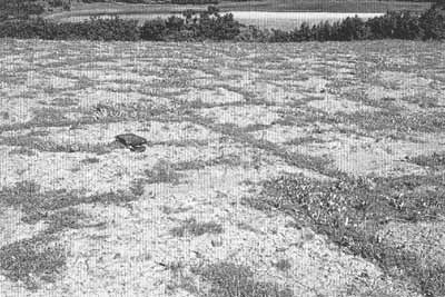
Plate 6.3 Patterned ground: non-sorted polygonal net in loamy deposits
with scanty vegetation in frost cracks. The Taymyr peninsula (photo: N. Tumel)
Sorted and unsorted patterned ground can form nets of circles on flat surfaces and
steps or stripes on hillslopes. They are created by different processes in the active
layer: frost cracking, contraction, heave resulting from cryostatic pressure and ice
segregation in winter; ice-melting and dilation subsidence in summer; and frost sorting
around the year. The origins of patterned ground are still under discussion and Corte
(1966), Washburn (1973, 1979), Jahn (1975), Pissart (1987), and French (1996) provide
detailed reviews of various hypotheses. Patterned ground most often has the following
morphology: spot-medallions which may be surrounded tussocks, flat, curved or convex
heaves (which have a size range between 0.5 m and 2.0 m) and hummocks. They are typical of
mineral and peaty soils of relatively well-drained tundra terrains and are widespread on
the accumulative plains of northern Europe, Western Siberia, and the Taymyr peninsula.
Sorted patterned ground (circles, garlands, nets, and polygons) is found on ground rich in
coarse-grained material which is located close to the surface. It is typical of the Arctic
islands, flat summits, and pediment-like forms of tundra plateaux and nival mountainous
belts (Popov, 1967).
<<< Ground Ice | Physical Geography Index | Climate and
Permafrost >>>
|


