Please put an active hyperlink to our site (www.rusnature.info) when you copy the materials from this page
Physical Geography of Northern Eurasia
Rivers, Lakes, Inland Seas, and Wetlands
<<< Lakes Ladoga and Onega |
Physical Geography Index | Wetlands
>>>
The Black Sea and Sea of Azov
Northern Eurasia is surrounded by fourteen seas (Figure 5.1) with a combined area of
about 11 million km2 (see Avakyan and Shirokov, 1994).
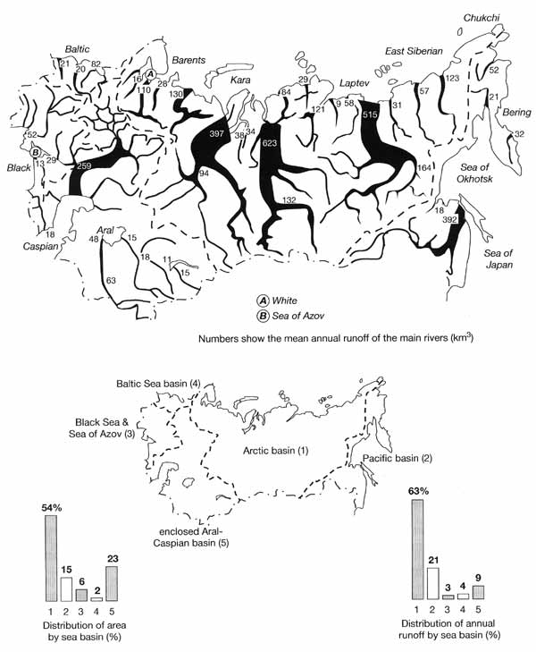
Fig. 5.1 Runoff of the main rivers and its distribution by sea basins.
Modified from Sokolov (1964)
Seas of the Arctic and Pacific Oceans are discussed below while other volumes of this
series are concerned with the Baltic. This chapter discusses the Black Sea and Sea of Azov
which occur far inland and have limited connection with the World Ocean. The Black Sea is
connected with the Sea of Marmara and the Mediterranean only through the narrow (0.76-3.6
km wide) and shallow (32-34 m deep at the junction with the Sea of Marmara) Bosporus
Strait. The Sea of Azov is connected to the Black Sea by the shallow Kerch Strait and is
often regarded as a gulf of the Black Sea. The Black Sea is the world's largest
permanently anoxic basin. Understanding of its unique environment is extremely important,
first, because it may provide insight into the past conditions in the World Ocean and
second, because the oxic-anoxic interface may be sensitive to changes in the water balance
of the sea with potentially damaging consequences.
Anoxic conditions develop in response to a specific water balance of the Black Sea and
the exchange with the Mediterranean. Salinity of the mixed surface layer in the Black Sea
is low, about 18 ppt, because the sea receives relatively high precipitation and river
inflow while evaporation is relatively low (Table 5.8).
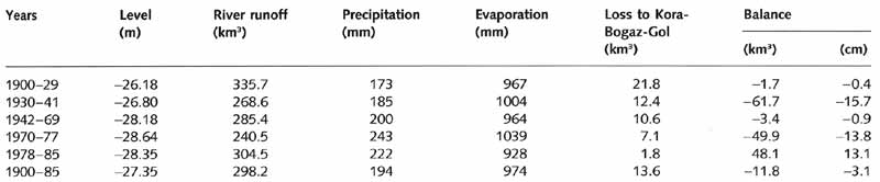
Table 5.8 Components of the water balance of the Caspian Sea between
1900 and 1985. Source: Kosarev and Makarova (1988).
Water of the upper layer flows from the Black Sea to the Sea of Marmara through the
Bosporus Strait while a more dense and saline (about 35 ppt) water of Mediterranean origin
flows in the opposite direction at lower levels. Strong salinity stratification and weak
vertical water exchange develop, preventing ventilation of the deep water whose oxygen
content is exhausted through the decay of the settling organic material. Oxidation under
anaerobic conditions occurs using the oxygen of sulphate ions and the water becomes
enriched in hydrogen sulphide (H2S). The major supply of hydrogen ions is
through the dissociation of carbonic acid. The sea, therefore, is stratified into two
distinct zones: the upper oxygenated layer which extends to a depth of 100-200 m and the
deep anoxic layer where oxygen is replaced by H2S (Figure 5.11).
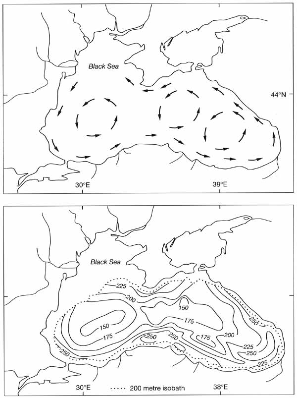
Fig. 5.11 Water circulation in the Black Sea and topography of the upper
hydrogen sulphide boundary (m). Modified from Codispoti et al. (1991)
Already at a depth of approximately 300 m, oxygen is found to be depleted to zero
concentrations while H2S builds up. A steep pycnocline, which occurs between
the two zones, provides a barrier to mixing and maintains the stability of the oxic-anoxic
boundary. The change from oxic to anoxic conditions in the Black Sea occurred about the
time of the postglacial climatic optimum when a rise in the level of the Mediterranean
restored the inflow of saline water (Deuser, 1972; Ross and Degens, 1974).
The topography of the boundary between the oxic and anoxic waters is the most important
control over life in the Black Sea. It is not surprising, therefore, that a possible rise
of the boundary remains a central question in research on the Black Sea environment. The
position of the oxic-anoxic interface depends mainly on the salinity profile and may be
sensitive to changes in the water balance of the sea. Although this is a controversial
issue, it is not inconceivable that changes in the water balance may lead to a rise of the
H2S zone. Such changes may occur as a result of natural climatic variability,
global warming, and human interference. In particular, there is a concern over potential
effects of the water abstraction which in the mid-1980s reached 10 per cent of the total
river inflow (Zhorov et al., 1984; Zhorov and Boguslavsky, 1985; Faschuk and Ayzatullin,
1986; Bryantsev et al., 1988; Murray et al., 1989). At present, there is no definite
concept of the H2S zone dynamics, partly because the historical information is
either lacking or is insufficiently accurate, and partly because there are distinct
seasonal fluctuations which depend upon both circulation and biotic factors (Mandych et
al., 1995). A comparison between the measurements made in the 1960s and the late 1980s
suggests that there has been only a marginal change in the depth of the H2S
boundary (Codispoti et al., 1991).
Spatial patterns of the oxic-anoxic interface and seasonal variability in its depth are
better researched. The water circulation system in the Black Sea consists of large closed
cyclonic gyres which form inside the Main Black Sea current (Figure 5.11). There are also
smaller anticyclonic eddies developing between the coast and the Main current, which runs
at a distance of 20-30 km from the shore. It is known that the depth of the H2S
boundary may vary by about 100 m in the centres of cyclonic and anticyclonic gyres
(Sorokin, 1983; Mandych et al., 1995). The maximum depth occurs in the centre of an
anticyclonic eddy in the south-eastern sector of the sea while the minimum depth occurs
near the centres of the cyclonic eddies (Figure 5.11).
In winter and late autumn, a decline in the depth of the boundary is observed in
contrast to spring and summer. Seasonal fluctuations apparently result from an increase in
oxygen solubility and a decrease in the rates of organic matter destruction during the
cold season as well as from stronger water dynamics which intensify the aeration (Sorokin,
1983; Mandych et al., 1995).
Heavy pollution of the coastal waters by organic compounds and eutrophication have a
detrimental effect on the oxygen regime of the sea. The northwestern part of the basin is
under the strongest pressure because it receives about 80 per cent of the total river
runoff (from the major industrial and agricultural regions), and because of the impact of
the largest ports of Odessa and Novorossiisk. In recent years, the beaches of the western
Black Sea were repeatedly 'closed' by the sanitary inspectorate and the state of the
coastal environment is considered as critical. Pollution has had a strong impact on the
population of dolphins, which has declined from 2-2.5 million in the 1930s to about 100
000 in the late 1980s, despite all attempts to protect this species (Kuksa, 1994).
In its natural condition, the Sea of Azov was one of the most productive water bodies
in Northern Eurasia. Because of the ample river runoff (mainly from the Don and the Kuban)
there was a stable supply of a large amount of nutrients. Water had a low salinity (about
10 ppt prior to intensive changes in river runoff with the exception of the Gulf of
Sivash), the sea was well heated and, with an average depth of 7 m, it was well
illuminated. The productivity of the sea reached 8 tonnes km-2 (Bronfman, 1995)
and until the 1950s the fish productivity of the sea was above 0.2 million tonnes per
annum (Ratkovich, 1993). However, because the sea regime is primarily controlled by river
runoff and the water exchange with the Black Sea is restricted, the Sea of Azov ecosystem
proved extremely sensitive to human impacts. The sea receives runoff from a vast
economically developed catchment, which is nineteen times larger than the area of the sea,
and river discharge is equivalent to 13 per cent of the sea volume, which is much higher
than for other seas. At the end of the 1980s, this region produced 22 per cent of the
agricultural products and 17 per cent of the industrial goods of the FSU, including 30 per
cent of its coal, 25 per cent of its steel, and 15 per cent of its mineral fertilizers and
plastics (Bronfman, 1995). Over 50 per cent of river runoff was used by industry and over
70 per cent of the catchment was under agricultural production, which significantly
modified the chemical composition of the water. The hydraulic developments on the
tributaries (in particular, the Tsimlyansky reservoir constructed on the Don in 1953) and
irreversible water abstraction, which reached 20 per cent of the annual runoff, reduced
river inflow by 33 per cent to 13.5 km3 a-1 (Bronfman and
Khlebnikov, 1985). As a result, the chemical class of water changed from the
hydrocarbonate class of the calcium group to the chloride-sulphate class of the sodium
group. Salinity increased to 14.0-14.5 ppt in the early 1970s, which was a period of low
precipitation and it was the onset of a phase of high precipitation in 1977 that helped to
stabilize salinity at 11.2-11.9 ppt (Bronfman, 1995).
Pollution (including pesticides) and an increase in salinity were the major factors
behind a dramatic decline in fish stocks. Out of 114 fish species and subspecies, 42 are
fresh-water species whose area of habitat has been sharply reduced. In addition, the
reduction in spring floods due to the regulation of runoff has affected spawning grounds
of diadromous and semi-diadromous fish and the existence of sturgeon in the Sea of Azov at
present is almost entirely due to the fish farms. During the period of high salinity in
the mid-1970s, some Black Sea species migrated to the Sea of Azov. In particular,
outbursts of the jellyfish population occurred, with its total mass reaching 13.5 million
tonnes (Kuksa, 1994), which significantly reduced the biomass of the other species. From
the late 1980s, the predatory Atlantic ctenophore (Mnemiopsis leidyi), which is known to
consume over 80 per cent of the summer production of zooplankton, has developed in the
sea. It is believed that if M. leidyi becomes a permanent element of the Sea of Azov
ecosystem, a recovery of the ecosystem will be unlikely.
<<< Lakes Ladoga and Onega |
Physical Geography Index | Wetlands
>>>
|


