Please put an active hyperlink to our site (www.rusnature.info) when you copy the materials from this page
Physical Geography of Northern Eurasia
Rivers, Lakes, Inland Seas, and Wetlands
<<< River Regimes and Variability in
Runoff | Physical Geography Index | The
Thermal and Ice Regime >>>
Suspended Sediment and Mineralization
Regular observations of material transport by the rivers of Northern Eurasia began at
the beginning of the 20th century and substantial information has been accumulated and
analyzed. According to the latest estimates (Lvovich et al., 1991), sediment yield from
the whole territory of the FSU is 716 million tonnes a-1, 77 and 639 million
tonnes originating from European and Asiatic areas, respectively. In Asiatic rivers,
suspended sediment load is usually higher due to the higher erosion rates which amounts to
61 tonnes km2 in Asia and 15 tonnes km2 in Europe (the highest erosion rates of
560 tonnes km2 occur in the Caucasus mountains). For comparison, the global
total sediment discharge is 14.9 x 10⁹ tonnes a-1 while erosion rate averages
118 tonnes km2 (Lvovich et al., 1991).
With respect to discharge of suspended sediment, four zones are distinguished in
Northern Eurasia (Shamov, 1949). Typical of the first zone, which covers mainly northern
areas, are small loads which usually do not exceed 50 g m-3. Sediment loads in
the second zone, to which the forest-steppe and parts of the forest zone belong, vary
between 50 and 150 g m-3. The third zone is distinguished by high sediment
loads which may reach 500 g m-3. This zone extends across the steppe regions of the
European part and Western Siberia and high suspended sediment yields form in response to a
very high proportion of arable land which in some European regions exceeds 80 per cent
(see below) and which produces high erosion rates. In all three zones (with the exception
of the Far East where the summer maximum is observed) transport of suspended load peaks
during the spring floods when its values exceed those observed during the period of low
water by a factor of 10-30. On average, during the spring floods rivers transport up to
80-90 per cent of the annual total. The fourth zone, covering the mountains of the
Caucasus and Central Asia, is distinguished by very high sediment loads (500-5000 g m-3).
During floods, sediment load may reach 100 000 g m-3. Mud floods are frequent
here. Values of the specific sediment discharge, which is a good indicator of erosion
rates, vary between less than 5 tonnes km2 in the north and 500 tonnes km2
in the southern mountains. The Amudarya has the highest specific sediment yield followed
by the Kura and the Volga (Table 5.3).
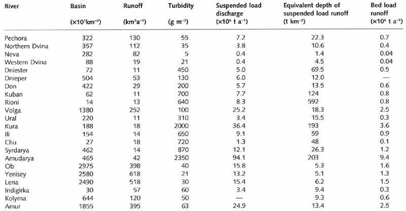
Table 5.3 Characteristics of sediment discharge
Sediment yields in rivers like the Volga, which has many dams and reservoirs, have been
reduced in comparison with what they would have been in the absence of such structures.
In most rivers of Northern Eurasia, water has low mineralization. In rivers, draining
about three quarters of the whole territory, mineralization is lower than 200 mg l-1
(Alekin, 1970; Nikanorov, 1990). Across large areas of the European north and Siberia,
which have abundant moisture supply and flat terrain, it is lower than 50 mg l-1
and these waters belong to the carbonate type. Rivers with sulphate and chloride types of
mineralization drain approximately 10 per cent of the territory and are concentrated
mainly in the southern steppe. Alekin (1970) estimates that the total annual ionic
discharge by rivers of Northern Eurasia averages 384 million tonnes which is nearly two
times less than the total sediment discharge (as estimated by Lvovich et al., 1991). The
transport of organic substances averages approximately 80 million tonnes a-1
and those of mineral colloids and organic biogenic elements are about 20 and 2 million
tonnes a-1, respectively (Alekin and Brazhnikova, 1964).
With respect to regional patterns of partitioning between suspended and dissolved load,
dissolved load dominates in rivers draining forested plains. Between 65 per cent and 85
per cent of all load carried by the rivers of the forest zone is dissolved load while in
the forest-steppe and steppe its proportion declines to 40-50 per cent (Figure 5.7).
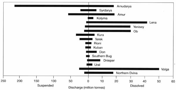
Fig. 5.7 Discharge of suspended and dissolved load. Modified from
Sokolov (1964)
In those rivers which originate in the mountains and flow through the desert, such as
the Amudarya, the opposite is true. Rates of chemical weathering, which lead to solute
production, are relatively modest, whereas erosion rates, which produce suspended material
are relatively high.
<<< River Regimes and Variability in
Runoff | Physical Geography Index | The
Thermal and Ice Regime >>>
|


