Please put an active hyperlink to our site (www.rusnature.info) when you copy the materials from this page
Physical Geography of Northern Eurasia
Climate at Present and in the Historical Past
<<< Evaporation | Physical
Geography Index | Snow cover >>>
Droughts and Associated Climatic Hazards
Droughts are perhaps the most serious and damaging of all climatic hazards. Droughts
affect mainly the southern part of Northern Eurasia, extending northwards in the Yana and
Lena basins (Figure 3.11).
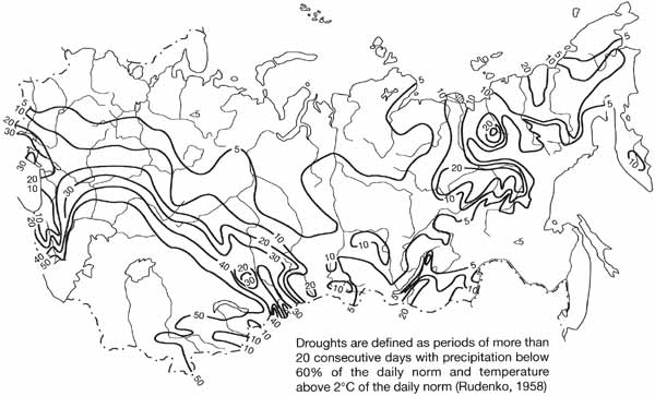
Fig. 3.11 Frequency of droughts (% of all years) between the middle of
the 19th and 20th centuries. Modified from Rudenko (1958)
It is the south, the forest-steppe and steppe zones, that are the main regions of
arable agriculture and, consequently, droughts have profound implications for food
production and human welfare. Associated with droughts are such phenomena as sukhovey
(dry, hot wind) and dust storms which further exacerbate the impacts of hot, dry weather
and often destroy crops. An enormous effort has been devoted to the study of droughts and
associated hazards, atmospheric processes causing droughts, their prediction and methods
used to minimize the effects of droughts on crops. Studies of droughts date back to the
middle of the 18th century. Systematic research began in the second half of the 19th
century and was prompted further by the succession of droughts that affected the central
and southern regions of the European territory in 1890, 1891, and 1892. The drought of
1891 lasted from May to August and spread as far north as the middle course of the Kama
and the Vyatka, affecting a population of more than 30 million (Buchinsky, 1976).
Two types of droughts are distinguished: soil drought and atmospheric drought. (This
discussion does not include physiological droughts, that is, those conditions when
moisture is available but plants are incapable of using it. Physiological droughts affect
healthy plants under the low temperatures and are most widespread in the Arctic and in the
high mountains.) Atmospheric droughts occur when temperatures remain high for a
considerable period of time predetermining high potential evaporation while precipitation
is low. Two additional factors control soil droughts: precipitation during the cold part
of the year and the amount of snow and ground water availability. Due to the stable snow
cover, a watertable that is close to the surface and, in the case of the Asiatic part of
the region, permafrost, severe deficits of soil moisture do not affect the northern part
of Eurasia (Figure 3.12a).
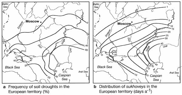
Fig. 3.12 Frequency of soil droughts and distribution of sukhoveys (dry,
hot winds) in European territory. Modified from Buchinsky (1976)
The early students of droughts attributed atmospheric droughts exclusively to the
advection of hot, dry air from the Caspian region and Central Asia. However, the main
factor in the formation of droughts is the prolonged persistence of high pressure, which
disrupts zonal flow, and local transformation of air. Discussing the origin of droughts in
the context of the East European plain, Buchinsky (1976) points out that it is not the
tropical air but the Arctic anticyclones, which advance from the Barents or even from the
Kara Sea and become stationary over the plain, that provide ideal conditions for the
development of droughts. Over 70 per cent of all droughts in the central part of European
Russia and the Volga region are associated with these high pressure systems (Klimenko,
1996). Similar to all other blocking highs, the Arctic anticyclones prevent the normal
eastwards propagation of moisture-bearing frontal systems and curtail rainfall. In
addition to this common factor, the Arctic anticyclones draw in air from the Arctic Seas.
In contrast to the air advected along the periphery of the Azores high, the arctic air is
initially cold and, consequently, has a low moisture content. Should high pressure persist
over the continent for a long time and a soil moisture deficit develop, moisture input
through evaporation will be reduced. The fresh arctic air, which brings in little
moisture, enhances dry conditions over the central East European plain. The Azores high,
which extends to the East European plain in summer, plays an important role in the
development of droughts in Moldova and the Ukraine (Volevaha and Koshelenko, 1969).
The severity of droughts depends on the duration of anticyclonic weather. One of the
worst modern droughts occurred in the summer of 1972 (Fedorov, 1973; Buchinsky, 1976). An
anticyclone, centred over Moscow, established over the East European plain in May and
persisted throughout the summer, blocking the passage of Atlantic depressions. The
drought, which started in the south-eastern Ukraine and in the lower courses of the Don
and the Volga, had spread as far as Karelia by the middle of July. The prolonged
transformation of air, aided by the advection from Caspian deserts which became
established with the expansion of the blocking high, resulted in extremely dry, hot
weather. The southeastern Ukraine, central Russia, and the Volga region received 20-30 per
cent of the average summer rainfall while monthly temperatures exceeded the norms by
3-7°C. Daytime air temperatures were above 30-35°C while relative humidity dropped to
10-20 per cent. In addition to the widespread loss of crops, the extension of the drought
far north resulted in extensive forest and peat fires. Droughts as severe as this occur on
average once in a hundred years.
The sukhovey, a dry, hot wind, is an important phenomenon in the drier regions of
Eurasia and is a typical attribute of prolonged periods of dry weather. Although in the
European territory, sukhoveys are usually south-easterly winds, their origin is more
complex than simple advection from the Caspian and Central Asian deserts. Trajectory
analysis has shown that over 50 per cent of air flows that produce sukhoveys originate
over the Arctic seas and have an original temperature of about 10°C and a relative
humidity of about 60 per cent (Volevaha and Romushkevich, 1971). As the air, circulating
around the periphery of a high pressure system, passes over the continent it warms at a
rate of 2-5°C day-1, while relative humidity drops at a rate of 5-10 per cent
day-1. By the time the wind changes its direction from northerly to
south-easterly over the Caspian deserts, it becomes hot and dry, these characteristics
being enhanced by the influence of the deserts. Adiabatic descent in high pressure systems
contributes to the formation of sukhoveys. As little as 10 per cent begins in Central Asia
and Iran. Figure 3.12b gives frequency of sukhoveys, defined as wind with a speed
exceeding 5 m s-1, a daytime temperature above 25°C, and a relative humidity
below 30 per cent, for the East European plain. Sukhoveys occur between April and
September, peaking in high summer but being particularly damaging to young crops in
April-June. They usually last for 2-4 days but the extreme events span two to three weeks
(Buchinsky, 1976).
<<< Evaporation | Physical
Geography Index | Snow cover >>>
|


