Home

Physical Geography
  Tectonics and Geology
  Climatic Change
  Climate at Present and in the Past
  Soils
  Rivers, Lakes, Seas and Wetlands
  Permafrost
  Biodiversity

Biomes & Regions
  Arctic Environments
  Boreal Forests
  Mixed and Deciduous Forests
  Steppe and Forest-steppe
  Arid Environments
  The Mountains of Northern Russia
  The Mountains of Southern Siberia
  The Caucasus
  The Mountains of Central Asia
  Lake Baikal
  The Far East

Environmental Problems
  Radioactive Contamination
  Oil and Gas Development
  Air Pollution
  The Aral Sea Problems
  Deforestation and Degradation of Forests
  Nature Protection and Conservation

Images of Russian Nature
  Geographic Index
  Systematic Index
  Alphabetical Index

Nature Reserves
  Northern Russia
  Central Russia
  Povolzhye (Volga river basin)
  Southern Russia
  Ural Mountains
  Western Siberia
  Eastern Siberia
  Far East


Ôîòîãðàôèè ïðèðîäû Ðîññèè
  Ãåîãðàôè÷åñêèé êàòàëîã
  Ñèñòåìàòè÷åñêèé êàòàëîã
  Àëôàâèòíûé êàòàëîã


Nature Landscapes of the World
  Europe
  Asia
  North America
  South America
  Africa
  Australia
  Antarctic

Field Ecology Education
  Instructive Videos
  Instructive Manuals


Ýêîëîãè÷åñêèé Öåíòð Ýêîñèñòåìà íà Facebook Ýêîëîãè÷åñêèé Öåíòð Ýêîñèñòåìà ÂÊîíòàêòå

Þòóá êàíàë Ýêîñèñòåìà YouTube EcosystemaRu

Ñêà÷àòü íàøè ïðèëîæåíèÿ èç ìàãàçèíà RuStore
Ñêà÷àòü íàøè ïðèëîæåíèÿ èç ìàãàçèíà RuMarket Ñêà÷àòü ïðèëîæåíèÿ Ýêîñèñòåìû èç ìàãàçèíà NashStore
Ñêà÷àòü ïðèëîæåíèÿ Ýêîñèñòåìû èç ìàãàçèíà GetApps Xiaomi
Ñêà÷àòü ïðèëîæåíèÿ Ýêîñèñòåìû ÝêîÃèä èç ìàãàçèíà Google Play / Play Market
Ñêà÷àòü ïðèëîæåíèÿ Ýêîñèñòåìû ÝêîÃèä èç AppStore / iTunes
Âèäåî-360 ïî ýêîëîãèè íà íàøåì Youtube êàíàëå

Bird Decoys for European Birds: Songs, Calls, Sounds, Bird voices - application for Android download from Google Play / Play Market for free


Share this page with your friends:


( ) : : = = + +


Russian Nature

Home | Physical Geography | Biomes & Regions | Environmental Problems | Images of Russian Nature | Nature Reserves

Our Field Ecology Center published more than 180 methodical materials for nature studies. Some of them are in English:
Mobile educational application: Ecological Field Studies Techniques on Play.Google Mobile field guide Birds of North America: Songs and Calls Decoys on Play.Google WILD FLOWERS OF RUSSIA Field Identification Guide on Play.Google Mobile field guide Birds of Russia on Play.Google Mobile field guide Birds of Russia Songs, Calls and Voices on Play.Google Mobile field guide Birds of Europe Songs, Calls and Voices on Play.Google Mobile field guide Birds of Europe Songs, Calls and Voices on Play.Google
Mobile Educational Apps and Field Identification Guides for Russian, European and American Birds
Applications for Android and iOS are available at GooglePlay and AppStore


Please put an active hyperlink to our site (www.rusnature.info) when you copy the materials from this page

Physical Geography of Northern Eurasia

Climate at Present and in the Historical Past

<<< Precipitation | Physical Geography Index | Droughts and Associated Climatic Hazards >>>

Evaporation

Strong spatial and seasonal variations in temperature and moisture availability mean that both potential and actual evaporation vary spatially and temporally. The highest values of potential evaporation (about 2000 mm a-1) are observed in the deserts of Central Asia which receive the highest input of solar energy. Potential evaporation declines northwards reaching approximately 125 mm a-1 in the Siberian Arctic although topography and water bodies disrupt the latitudinal distribution. Low values occur in the Far East because of the humid climate and higher cloud cover which lowers the input of heat (Borisov, 1970). The distribution of actual evaporation, which is controlled by the availability of both heat and moisture, is different (Table 3.1).

Average potential and actual evaporation (mm a<sup>-1</sup>) and the proportion of net radiation spent on evaporation (%) in different physical-geographical zones

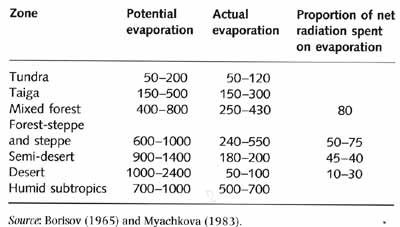
Table 3.1 Average potential and actual evaporation (mm a-1) and the proportion of net radiation spent on evaporation (%) in different physical-geographical zones

Deserts exhibit the lowest values of actual evaporation because of the lack of moisture and likewise low values occur in the tundra zone because of the lack of heat. Actual evaporation is the highest in the humid subtropics of Transcaucasia. Another maximum occurs in the mixed forest and forest-steppe zones of the European territory, the Ussuri basin in the Far East and in Western Siberia. Evaporation occurs between April and October and annual patterns reflect the distribution of evaporation during the warm season. Between November and February, actual evaporation is extremely low or virtually zero across most of Northern Eurasia with the exception of the Black and Caspian Sea regions, the Barents Sea, and the Pacific Seas. Only by March do monthly evaporation totals reach 10 mm in Central Asia and Transcaucasia as temperature increases and spring rainfall provides moisture. The spring evaporation patterns are extremely inhomogeneous because they depend on the presence of snow cover, the amount of snow and the rate of snow melt. It is the melt water that ensures that there is no soil moisture deficit in spring-early summer north of the Kiev-Moscow-Tobolsk-Irkutsk line.

<<< Precipitation | Physical Geography Index | Droughts and Associated Climatic Hazards >>>


Recommend this page to your friends:


* *