Please put an active hyperlink to our site (www.rusnature.info) when you copy the materials from this page
Physical Geography of Northern Eurasia
Tectonics and Geology of Northern Eurasia
<<< The Tectonic Regions | Physical Geography Index | The Siberian
Platform >>>
The East European Platform
The East European platform, originally distinguished in 1897 under the name of 'Russian
Plate' by A. P. Karpinsky, is limited in many places by the rectilinear zones of thrust
faults and tectonic sutures (Koronovsky, 1984). The basement of the platform is formed by
the metamorphic structures of the lower and upper Archean (more ancient than 2.6 billion
years) and lower Proterozoic (more ancient than 1.6 billion years), broken up by granitoid
intrusions.
The Archean and, partially lower Proterozoic sediments, forming the basement of the
East European platform, represent a series of originally sedimentary,
volcanogenic-sedimentary and volcanogenic rocks, which have been metamorphosed in various
degrees. The Archean formations are characterized by very drastic and specific folding,
related to the plastic flow of material under high pressures and temperatures. Such
structures as gneiss domes are often observed. The platform basement outcrops only on the
Baltic and Ukrainian shields, but elsewhere, particularly within the extensive anticlines,
it is known through boreholes and is geophysically well studied. For dissection of
basement rocks absolute age determinations are important. Within the limits of the East
European platform the most ancient rocks have an age of 3.5 billion years and more. These
form the major blocks within the basement, which are bounded by the younger fold zones of
the late Archean and early Proterozoic.
The platform cover is represented by two different complexes. The most ancient cover
within the span of the Riphean and lower Vendian, was deposited mostly within deep basins
(grabens, rifts or aulacogens) and consists of terrigenous sandy-clayey rocks with a
thickness of up to 5 km and is locally characterized by the development of basaltic
volcanic rocks. The younger cover (late Vendian-Phanerozoic) forms a gently sloping widely
spread sheet, composed of vast synclines and basins. The thickness of this complex ranges
from some tens of metres to 20-22 km within the most concave basins. The thickness of the
crust averages about 40 km, but locally varies between 28 km and 60 km. It decreases
beneath the Riphean and Paleozoic rifts and deep basins.
Within the platform, the Baltic and Ukrainian shields can be distinguished, as well as
the vast East European Plate, the basement of which is dissected with an amplitude from 10
km to 20 km. Within their boundaries a number of anticlines and synclines, as well as
other smaller structures (Figure 1.2) are distinguished.
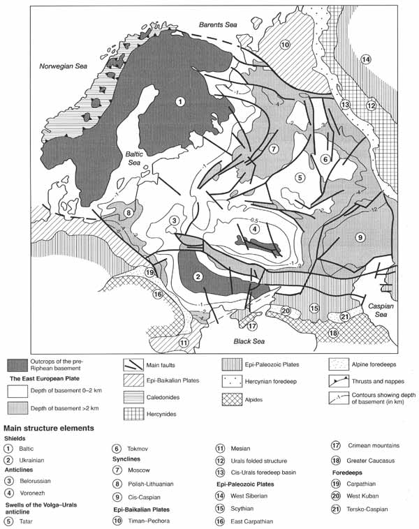
Fig. 1.2 Main structures of the East European platform
The platform basement structure is defined by a frame of early Archean heterogenous
blocks, formed by highly metamorphosed rocks, and bounded by folded late Archean and early
Proterozoic zones. All these diverse structural elements were welded into a single whole
by the end of the early Proterozoic and were subjected to tectonic crushing, especially in
the west, as well as the intrusion of rapakivi granites and locally strong ignimbrite
volcanism. The most ancient crust, in the form of 'grey gneiss', with an age of over 3.5
billion years, is known in the Kola peninsula and on the Baltic and Ukrainian shields. The
Archean complexes (3.5-2.6 billion years) are represented by various thicknesses of
gneisses, granites, and crystalline schists, as well as a greenstone belt with
iron-schistic deposits, which were subjected to multiphase metamorphism (Rundkvist and
Mitrofanov, 1988).
The lower Proterozoic sequences are relatively poorly developed within the platform
basement, as well as within the shields, and differ sharply from the most ancient Archean
sequences, forming either linear fold zones or isometric basins. Within the Baltic shield
above the Archean complexes, the sequences are deposited with an obvious lack of
conformity, represented by terrigenous rocks and metabasites closely related to the upper
deposited conglomerates. These are essentially volcanogenic sequences, with the
conglomerates within the top zone having a thickness of up to 2.5 km. The prevailing
originally basaltic, andesite-basaltic, and rarely, more acid volcanites are related to
the grabens (Khain and Bozhko, 1988).
Following weak phases of folding occurring about 2.3 billion years ago, the region of
the modern Baltic shield entered a new stage of its development. The formation of a
weathering crust was preceded by the accumulation of relatively thin-skinned sequences.
These sediments are represented by the quartz conglomerates, gravelites, sandstones, and
quartzites with tracks of ripples and drying joints. The sedimentary continental rocks are
interlayered with the basalt covers. The sediments, deposited above, are formed at the
bottom by clayey schists, phyllites, and dolomites; in the middle part by covers of
olivine and toleiitic basalts and picrites; while in the upper parts sandstones and
tuffoschists predominate. Still higher, conglomerates and polymictic sandstones with sills
of gabbro-diabases (1.1-1.8 billion years) are located. The total thickness of all these
sediments averages 1-1.2 km. They all are deposited almost horizontally and are intruded
by rapakivi granites (1.67 billion years).
Within the Ukrainian shield, the lower Proterozoic consists of the well-known Krivoy
Rog series. Superimposed over the Archean complexes, this forms fault-line synclinoria
with a width of 10-50 km. The Krivoy Rog series is subdivided into a lower terrigenous
sequence (quartzite-sandstones, conglomerates, phyllites, graphitic schists); a middle one
(iron ore, consisting of rhythmically alternating jaspilites and schists, resembling
flysch); and the top one, which is mainly terrigenous (conglomerates, gravelites, and
quartzites). The total thickness of the series is 7-8 km. Its deposits are intruded by
granites with an age of 2.1-1.8 billion years (Khain and Bozhko, 1988). Analogous to the
above formations on the Voronezh anticline are the sediments of the similar three-membered
Kursk series, with the iron ore sequence in the middle part forming narrow sinclinoral
zones, orientated meridionally and well traced in the magnetic anomaly field.
During the Riphean (1.65-0.56 billion years), at the beginning of platform cover
formation, the uplifted platform basement was subjected to some extension, with the
formation of rift zones. Aulacogenes were filled with a series of red-coloured,
continental shallow marine, and lagoonal mottled sediments in the course of almost a
billion years. (Figure 1.3, I, IV). Locally, basic volcanism was exposed (Milanovsky,
1987).
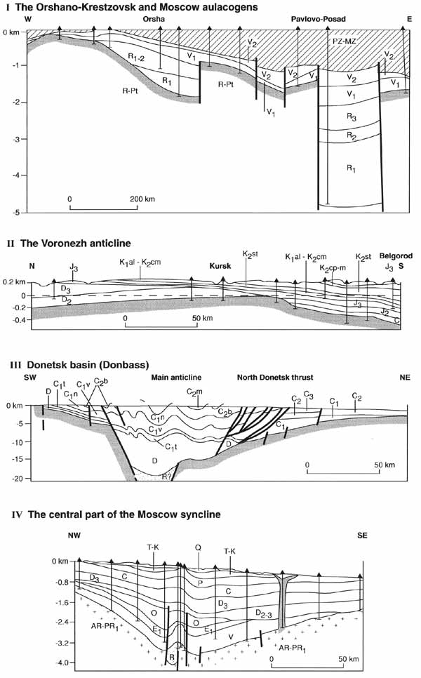
Fig. 1.3 Geological sections of the East European platform
The lower parts of the stratigraphic sequences of the lower Riphean series are formed
by coarse grained terrigenous red-coloured sediments, which accumulated under continental
conditions. They are represented by conglomerates, gravelites, variously grained
sandstones, aleurolites, and argillites. Within the upper part of the stratigraphic
sequences, beds of finer rocks appear, predominantly glauconite sandstones, argillites,
inter-layers of dolomites, limestones, and marls. The presence of stromatolites and
glauconite indicate the shallow marine nature of these sediments. Locally, in the lower
Riphean, volcanogenic rocks are recognized (basaltic ashes, tuffs, and basalt covers),
whereas in the western regions of the platform gabbro-diabase intrusions were introduced
at that time. The thickness of the lower Riphean deposits amounts to hundreds of metres,
often a kilometre. Within the Moscow aulacogene it reaches 1.5 km and in Kama-Belsk, 2-3
km.
Middle Riphean deposits are distinguished in the east of the platform and are
represented by terrigenous red-coloured rocks: red, pink, violet, and brown sandstones,
aleurolites, and argillites with interlayers of limestones and dolomites. The thickness of
middle Riphean deposits is 1.4 km in the Moscow aulacogene, whereas in other sites it does
not exceed 0.5-0.7 km. In the western regions of the platform, basaltic and
alkaline-basaltic outflows, and explosive eruptions occurred as suggested by the
interlayers of tuffs and tuffobreccias. The volcanic activity was accompanied by the
intrusion of bedded intrusions of gabbro-diabases. Upper Riphean deposits are widely
developed in the eastern and central regions of the platform and in the south-west. The
bottom zones of the stratigraphic sequences are represented by red-coloured and mottled
terrigenous rocks — sandstones, aleurolites, and argillites, formed under continental
conditions. The middle and upper parts of the stratigraphic sequences are usually formed
by green, grey, locally almost black sandstones, often glauconitic, aleurolites, and
argillites. Locally, beds of dolomites and limestones appear. The main part of the upper
Riphean sediments accumulated under shallow marine basin conditions. The thickness of the
upper Riphean sediments is 0.6-0.7 km, but frequently averages a few hundred metres. Thus,
in the Riphean within the East European platform, aulacogenes existed that dissected the
uplifted basement of the platform and were filled by series of red continental, shallow
marine, and lagoonal mottled sediments.
The general complexity of facies accumulation is typical for all the Riphean deposits,
but at the beginning of the early, middle, and late Riphean more coarse-grained
continental series accumulated. During the early and middle Riphean, uniform sediments
were formed with extensive oligomictic sands and sandstones. Only in the late Riphean did
more varied sediments begin to be deposited, among which were the polymictic sandstones,
aleurolites, and rarely dolomites and marls. In the shallow water reservoirs of the
Riphean, extensive vegetation existed. During the Riphean the climate changed from hot and
arid to cold. The platform as a whole was uplifted, but its contours were stable. This
stable uplifted position was disturbed only in the Vendian, when the character of the
tectonic movements changed and the climate became colder.
The upper part of the platform cover proper is divided into three complexes: (1) upper
Vendian-lower Devonian; (2) middle Devonian-upper Triassic; and (3) lower
Jurassic-Cenozoic. The time of formation of these complexes relates to the Caledonian,
Hercynian, and Alpine stages of development, and the boundaries between them correspond to
similar epochs of folding.
During the upper Vendian, Cambrian, Ordovician, Silurian, and early Devonian, within
the limits of the East European platform as a whole, uplifts dominated, which, beginning
with the Cambrian, successively occupied a greater area. Subductions were most manifest in
the western part of the platform, within the Baltic and Dniester basins. In the late
Silurian-early Devonian the formation of upthrows, locally grabens, occurred. Platform
inversion uplift occurred, oriented sublatitudinally. At that time, which corresponds to
the Caledonian epoch, the climate was hot or warm, which along with the shallow basins
favoured the development of diverse fauna.
The next, Hercynian stage, the duration of which is about 150 million years, was
accompanied by the reconstruction of the structural plan, crushing of the basement and
development of alkali-basaltic, ultrabasic-alkalic, and trap volcanism. The total
thickness of the sediments varies between 0.2 and 0.3 km and over 10 km (within the
Cis-Caspian basin).
The structural plan in the course of the Hercynian changed slightly and the uplifted
areas by the end of the stage had gradually spread but, by and large, subductions
prevailed on the platform, especially at the beginning of the stage, which sharply
differentiated it from the Caledonian. From the mid-stage the basin's orientation was
meridional and the basin areas were pushed towards the east, due to the influence of the
Hercynian syncline of the Urals. At the end of this stage the East European Plate was
formed within boundaries that were close to the modern ones and the basic structures were
formed, including local ones. The lower parts of the stratigraphic sequence of the
Hercynian complex are formed predominantly by terrigenous sediments which are locally
saline. In the middle of the sequence the carbonate series are widely spread, again
represented by terrigenous, red, rarely saline sediments in the upper parts. At the end of
the Hercynian, the development of salt domes within the Ukraine and Cis-Caspian basins
began. During the whole stage the climate remained hot with alternating humid and arid
phases.
The Alpine complex of the platform is represented by sediments, which formed between
the lower Jurassic and Quaternary. The duration of this complex formation is 190 million
years. The beginning of the stage marked the essential reconstruction of the tectonic
plate, expressed by the formation, in the East Russian basin, of a stable area of uplift.
Similar zones of uplift appeared in the meridional strip, approximately from Voronezh to
Stavropol (Figure 1.3, II).
The area of dominant subsidence, especially from the second half of the Cretaceous,
relates to the southern part of the platform. In the course of the whole stage the uplift
areas gradually spread, until in the late Pliocene they embraced the whole territory of
the platform. In the lower parts of the Alpine complex the terrigenous rocks are dominant.
In the late Cretaceous they were exclusively carbonatic, while later, in the Cenozoic,
they were again terrigenous. An important characteristic of this stage are the great
glaciations, which encompassed the northern part of the platform in the Quaternary.
The sediments of the Quaternary system on the platform are represented by various
types: glacial, alluvial, and marine. The glacial formations were deposited as a result of
the threefold cover of glaciations and are represented by boulder clays. In the early
Pleistocene, the glaciers of the Oka glaciation reached the region of Moscow (about 55°N)
and Perm (about 58°N). In the middle Pleistocene, the maximum Dnieper glaciation spread
further south, reaching the valleys of the Don and Dnieper, to approximately 48°N. In the
late Pleistocene, the Valday glaciation reached the latitude of 56°20'N. Each glaciation
consisted of several phases of glacial advance and retreat, the latter marked by
interglacial sediments. The glaciation centres were located in Scandinavia and Novaya
Zemlya. Beginning with the Dnieper glaciation, moraine ridges of the successive
glaciations are located further to the north, reflecting the reduction of the ice sheet
and its total disappearence by the modern epoch. The glaciers totally disappeared between
the Dnieper and Valday and between the early and late Valday glaciations. Released from
the heavy load of the glacial cover, Scandinavia is still under rapid isostatic uplift.
Along the periphery of the glaciers in the south of the platform the accumulation of loess
loams occurred, with a thickness of some tens of metres. The marine Quaternary deposits
form a number of terraces on the coasts of the southern and northern seas. They are
represented by sandy-clayey rocks and pebbles. The Caspian Sea transgressions penetrated
northwards along the Volga valley in the early and middle Pleistocene. The Quaternary
history is discussed below.
Magmatism in the course of the Alpine stage was practically absent, though information
has appeared concerning Mesozoic volcanism on the southern slope of the Voronezh massif
(effusives with an age of 74 million years), the presence of a microdiorite dike in the
Donetsk basin (162-166 million years) as well as Oligocene lavas near Arkhangelsk (27 ±
1.6 million years).
It should be stressed that during the Alpine stage before the Jurassic, in the late
Cretaceous, before the Paleogene and during the Quaternary, tectonic movements of
inversion type occurred in a number of aulacogenes in the east of the platform, forming
many bars and uplifts. In the region of the lakes Ladoga and Onega, and the Kandalaksha
Bay, small grabens related to glacioisostatic movements, were formed.
<<< The Tectonic Regions | Physical Geography Index | The Siberian
Platform >>>
|


